Polkton elevation
Polkton (North Carolina, Anson County), United States elevation is 94 meters and Polkton elevation in feet is 308 ft above sea level [src 1]. Polkton is a populated place (feature code) with elevation that is 185 meters (607 ft) smaller than average city elevation in United States.
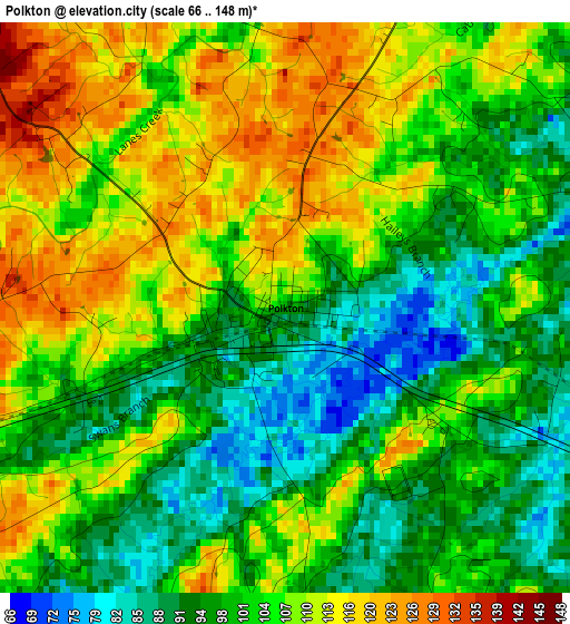
Below is the Elevation map of Polkton, which displays elevation range with different colors. Scale of the first map is from 66 to 148 m (217 to 486 ft) with average elevation of 103.6 meters (=340 ft) [note 1]
These maps also provides idea of topography and contour of this city, they are displayed at different zoom levels. More info about maps, scale and edge coordinates you can find below images.
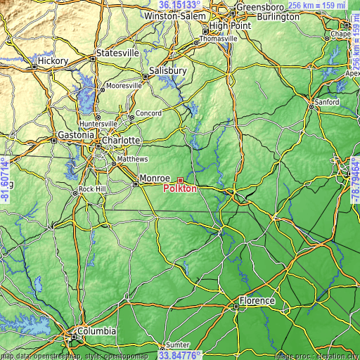
| \ | Map #1 | Topo.Map |
| Scale [m] | 66..148 m | × |
| Scale [ft] | 217..486 ft | × |
| Average | 103.6 m = 340 ft | × |
| Width | 8 km = 5 mi | 256.1 km = 159.1 mi |
| Height | 8 km = 5 mi | 256.1 km = 159.1 mi |
| ↑Max Latitude | 35.043637° | 36.15133° |
| Latitude at center | 35.00765° | 35.00765° |
| ↓Min Latitude | 34.971648° | 33.84776° |
| ← Min Longitude | -80.244835° | -81.60714° |
| Longitude center | -80.20089° | -80.20089° |
| →Max Longitude | -80.156945° | -78.79464° |
Nearby cities:
Cities around Polkton sort by population:
• Monroe elevation 179 m
31.9 km,  265°
265°
• Unionville 179 m
29.4 km,  287°
287°
• Wadesboro 155 m
12.1 km,  111°
111°
• Wingate 172 m
22.8 km,  263°
263°
• Pageland 197 m
31.3 km,  213°
213°
• Marshville 169 m
15.3 km, 261°
• Norwood 121 m
24.7 km,  17°
17°
• Oakboro 160 m
26.9 km,  334°
334°
• Burnsville 164 m
12.3 km,  341°
341°
• Stanfield 187 m
32.5 km,  320°
320°
• Chesterfield 90 m
31.9 km,  161°
161°
• Mount Gilead 123 m
29.3 km,  38°
38°
Multilingual:
 En español:
Polkton elevación 94 m.
 En France:
Polkton élévation 94 m.


Sources and notes:
- [note 1] Map square and city borders are not equal. Map elevation data is calculated only from area inside that square.
- [src 1] Elevation data from geonames database provided with same terms of usage.
- [src 2] The elevation map of Polkton is generated using elevation data from NASA's 3 arcsec (90m) resolution SRTM data.
- [src 3] Base (background) map © OpenStreetMap contributors tiles are generated by Geofabrik and OpenTopoMap.
Copyright & License:
This Polkton Elevation Map is licensed under CC BY-SA. You may reuse any part from this page, if you give a proper credit by linking to this URL:
 More info on terms of use page.