Stanfield elevation
Stanfield (North Carolina, Stanly County), United States elevation is 187 meters and Stanfield elevation in feet is 614 ft above sea level [src 1]. Stanfield is a populated place (feature code) with elevation that is 92 meters (302 ft) smaller than average city elevation in United States.
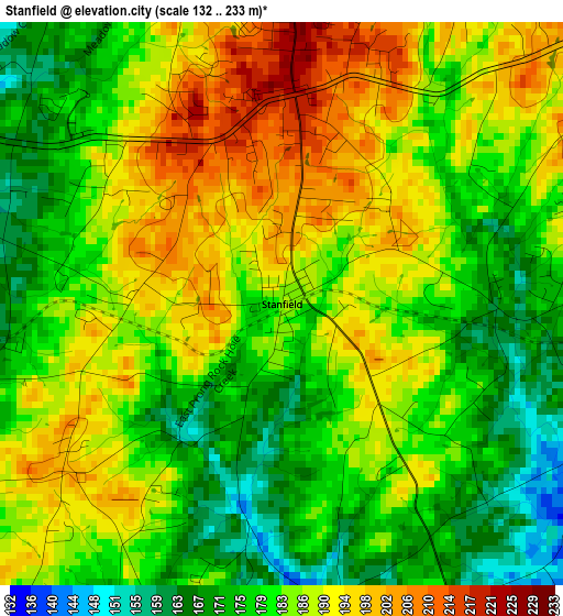
Below is the Elevation map of Stanfield, which displays elevation range with different colors. Scale of the first map is from 132 to 233 m (433 to 764 ft) with average elevation of 183.7 meters (=603 ft) [note 1]
These maps also provides idea of topography and contour of this city, they are displayed at different zoom levels. More info about maps, scale and edge coordinates you can find below images.
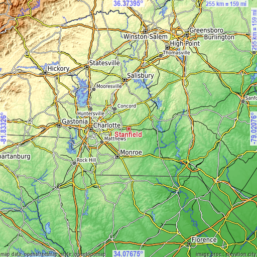
| \ | Map #1 | Topo.Map |
| Scale [m] | 132..233 m | × |
| Scale [ft] | 433..764 ft | × |
| Average | 183.7 m = 603 ft | × |
| Width | 7.98 km = 5 mi | 255.4 km = 158.7 mi |
| Height | 7.98 km = 5 mi | 255.4 km = 158.7 mi |
| ↑Max Latitude | 35.269367° | 36.37395° |
| Latitude at center | 35.23348° | 35.23348° |
| ↓Min Latitude | 35.197577° | 34.07675° |
| ← Min Longitude | -80.470955° | -81.83326° |
| Longitude center | -80.42701° | -80.42701° |
| →Max Longitude | -80.383065° | -79.02076° |
Nearby cities:
Cities around Stanfield sort by population:
• Concord elevation 209 m
24 km,  324°
324°
• Mint Hill 242 m
20.9 km,  253°
253°
• Albemarle 145 m
24.3 km,  57°
57°
• Harrisburg 197 m
23.2 km,  295°
295°
• Unionville 179 m
17.9 km,  204°
204°
• Fairview 161 m
14.6 km,  223°
223°
• Midland 156 m
6.7 km,  264°
264°
• Locust 222 m
2.9 km,  2°
2°
• Oakboro 160 m
8.9 km,  95°
95°
• Mount Pleasant 194 m
18.5 km,  357°
357°
• Hemby Bridge 193 m
23.3 km,  231°
231°
• Burnsville 164 m
21.4 km,  129°
129°
Multilingual:
 En español:
Stanfield elevación 187 m.
 En France:
Stanfield élévation 187 m.
 Auf Deutsch:
Stanfield höhe über dem Meeresspiegel ist 187 m.

Sources and notes:
- [note 1] Map square and city borders are not equal. Map elevation data is calculated only from area inside that square.
- [src 1] Elevation data from geonames database provided with same terms of usage.
- [src 2] The elevation map of Stanfield is generated using elevation data from NASA's 3 arcsec (90m) resolution SRTM data.
- [src 3] Base (background) map © OpenStreetMap contributors tiles are generated by Geofabrik and OpenTopoMap.
Copyright & License:
This Stanfield Elevation Map is licensed under CC BY-SA. You may reuse any part from this page, if you give a proper credit by linking to this URL:
 More info on terms of use page.