Mount Gilead elevation
Mount Gilead (North Carolina, Montgomery County), United States elevation is 123 meters and Mount Gilead elevation in feet is 404 ft above sea level [src 1]. Mount Gilead is a populated place (feature code) with elevation that is 156 meters (512 ft) smaller than average city elevation in United States.
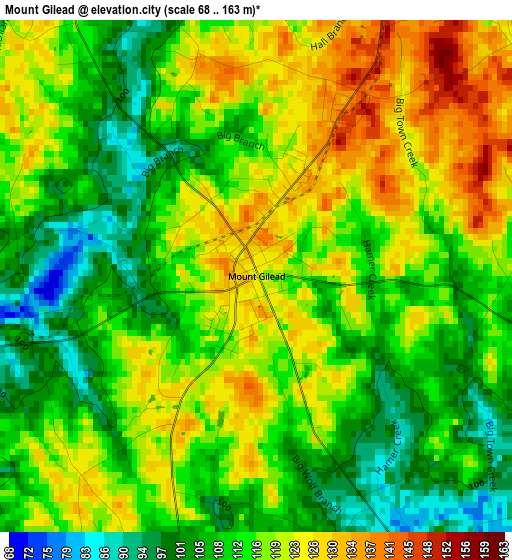
Below is the Elevation map of Mount Gilead, which displays elevation range with different colors. Scale of the first map is from 68 to 163 m (223 to 535 ft) with average elevation of 114.8 meters (=377 ft) [note 1]
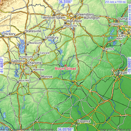
These maps also provides idea of topography and contour of this city, they are displayed at different zoom levels. More info about maps, scale and edge coordinates you can find below images.
| \ | Map #1 | Topo.Map |
| Scale [m] | 68..163 m | × |
| Scale [ft] | 223..535 ft | × |
| Average | 114.8 m = 377 ft | × |
| Width | 7.98 km = 5 mi | 255.5 km = 158.8 mi |
| Height | 7.98 km = 5 mi | 255.5 km = 158.8 mi |
| ↑Max Latitude | 35.250765° | 36.3556° |
| Latitude at center | 35.21487° | 35.21487° |
| ↓Min Latitude | 35.178959° | 34.05788° |
| ← Min Longitude | -80.046225° | -81.40853° |
| Longitude center | -80.00228° | -80.00228° |
| →Max Longitude | -79.958335° | -78.59603° |
Nearby cities:
Cities around Mount Gilead sort by population:
• Albemarle elevation 145 m
23.4 km,  309°
309°
• Rockingham 86 m
37 km,  145°
145°
• Wadesboro 155 m
28.3 km,  193°
193°
• Polkton 94 m
29.3 km,  218°
218°
• Troy 202 m
18.7 km,  31°
31°
• Norwood 121 m
10.6 km,  272°
272°
• Badin 159 m
23.6 km,  333°
333°
• Oakboro 160 m
29.7 km, 272°
• Cordova 88 m
37.4 km, 153°
• Biscoe 187 m
25.8 km,  51°
51°
• Burnsville 164 m
24.8 km,  242°
242°
• Ellerbe 165 m
27.1 km,  126°
126°
Multilingual:
 En español:
Mount Gilead elevación 123 m.
 En France:
Mount Gilead élévation 123 m.
 Auf Deutsch:
Mount Gilead höhe über dem Meeresspiegel ist 123 m.

Sources and notes:
- [note 1] Map square and city borders are not equal. Map elevation data is calculated only from area inside that square.
- [src 1] Elevation data from geonames database provided with same terms of usage.
- [src 2] The elevation map of Mount Gilead is generated using elevation data from NASA's 3 arcsec (90m) resolution SRTM data.
- [src 3] Base (background) map © OpenStreetMap contributors tiles are generated by Geofabrik and OpenTopoMap.
Copyright & License:
This Mount Gilead Elevation Map is licensed under CC BY-SA. You may reuse any part from this page, if you give a proper credit by linking to this URL:
 More info on terms of use page.