Biscoe elevation
Biscoe (North Carolina, Montgomery County), United States elevation is 187 meters and Biscoe elevation in feet is 614 ft above sea level [src 1]. Biscoe is a populated place (feature code) with elevation that is 92 meters (302 ft) smaller than average city elevation in United States.
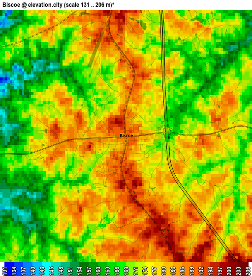
Below is the Elevation map of Biscoe, which displays elevation range with different colors. Scale of the first map is from 131 to 206 m (430 to 676 ft) with average elevation of 174.6 meters (=573 ft) [note 1]
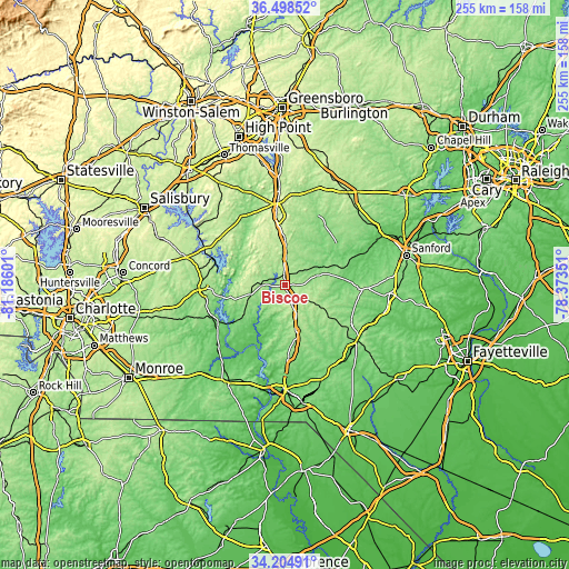
These maps also provides idea of topography and contour of this city, they are displayed at different zoom levels. More info about maps, scale and edge coordinates you can find below images.
| \ | Map #1 | Topo.Map |
| Scale [m] | 131..206 m | × |
| Scale [ft] | 430..676 ft | × |
| Average | 174.6 m = 573 ft | × |
| Width | 7.97 km = 5 mi | 255 km = 158.4 mi |
| Height | 7.97 km = 5 mi | 255 km = 158.4 mi |
| ↑Max Latitude | 35.395691° | 36.49852° |
| Latitude at center | 35.35986° | 35.35986° |
| ↓Min Latitude | 35.324013° | 34.20491° |
| ← Min Longitude | -79.823705° | -81.18601° |
| Longitude center | -79.77976° | -79.77976° |
| →Max Longitude | -79.735815° | -78.37351° |
Nearby cities:
Cities around Biscoe sort by population:
• Asheboro elevation 256 m
38.8 km,  355°
355°
• Albemarle 145 m
38.1 km,  268°
268°
• Pinehurst 161 m
33.6 km,  122°
122°
• Seven Lakes 176 m
21.5 km,  114°
114°
• Troy 202 m
10.4 km, 269°
• Whispering Pines 115 m
38.7 km, 107°
• Carthage 178 m
32.9 km,  92°
92°
• Norwood 121 m
34.5 km,  243°
243°
• Badin 159 m
31 km,  279°
279°
• Robbins 132 m
19.3 km,  64°
64°
• Mount Gilead 123 m
25.8 km,  231°
231°
• Ellerbe 165 m
32.1 km,  177°
177°
Multilingual:
 En español:
Biscoe elevación 187 m.
 En France:
Biscoe élévation 187 m.


Sources and notes:
- [note 1] Map square and city borders are not equal. Map elevation data is calculated only from area inside that square.
- [src 1] Elevation data from geonames database provided with same terms of usage.
- [src 2] The elevation map of Biscoe is generated using elevation data from NASA's 3 arcsec (90m) resolution SRTM data.
- [src 3] Base (background) map © OpenStreetMap contributors tiles are generated by Geofabrik and OpenTopoMap.
Copyright & License:
This Biscoe Elevation Map is licensed under CC BY-SA. You may reuse any part from this page, if you give a proper credit by linking to this URL:
 More info on terms of use page.