Carthage elevation
Carthage (North Carolina, Moore County), United States elevation is 178 meters and Carthage elevation in feet is 584 ft above sea level [src 1]. Carthage is a seat of a second-order administrative division (feature code) with elevation that is 101 meters (331 ft) smaller than average city elevation in United States.
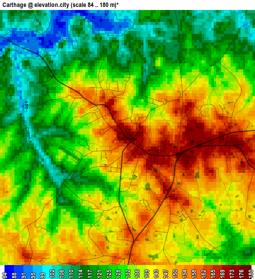
Below is the Elevation map of Carthage, which displays elevation range with different colors. Scale of the first map is from 84 to 180 m (276 to 591 ft) with average elevation of 134 meters (=440 ft) [note 1]
These maps also provides idea of topography and contour of this city, they are displayed at different zoom levels. More info about maps, scale and edge coordinates you can find below images.
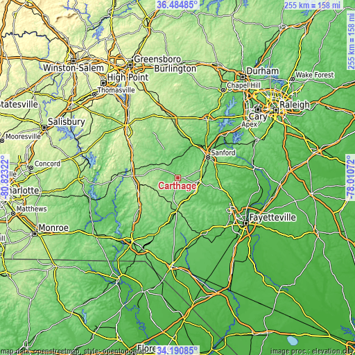
| \ | Map #1 | Topo.Map |
| Scale [m] | 84..180 m | × |
| Scale [ft] | 276..591 ft | × |
| Average | 134 m = 440 ft | × |
| Width | 7.97 km = 5 mi | 255.1 km = 158.5 mi |
| Height | 7.97 km = 5 mi | 255.1 km = 158.5 mi |
| ↑Max Latitude | 35.381827° | 36.48485° |
| Latitude at center | 35.34599° | 35.34599° |
| ↓Min Latitude | 35.310137° | 34.19085° |
| ← Min Longitude | -79.460915° | -80.82322° |
| Longitude center | -79.41697° | -79.41697° |
| →Max Longitude | -79.373025° | -78.01072° |
Nearby cities:
Cities around Carthage sort by population:
• Sanford elevation 111 m
26.1 km,  55°
55°
• Pinehurst 161 m
17.4 km,  195°
195°
• Southern Pines 155 m
19.2 km,  173°
173°
• Siler City 186 m
42.2 km,  354°
354°
• Aberdeen 101 m
23.9 km,  182°
182°
• Seven Lakes 176 m
15.3 km,  240°
240°
• Farmville 87 m
30.7 km,  35°
35°
• Whispering Pines 115 m
10.8 km,  157°
157°
• Biscoe 187 m
32.9 km,  272°
272°
• Pinebluff 130 m
26.7 km,  190°
190°
• Broadway 145 m
35.3 km,  69°
69°
• Robbins 132 m
18.3 km,  302°
302°
Multilingual:
 En español:
Carthage elevación 178 m.
 En France:
Carthage élévation 178 m.
 Auf Deutsch:
Carthage höhe über dem Meeresspiegel ist 178 m.

Sources and notes:
- [note 1] Map square and city borders are not equal. Map elevation data is calculated only from area inside that square.
- [src 1] Elevation data from geonames database provided with same terms of usage.
- [src 2] The elevation map of Carthage is generated using elevation data from NASA's 3 arcsec (90m) resolution SRTM data.
- [src 3] Base (background) map © OpenStreetMap contributors tiles are generated by Geofabrik and OpenTopoMap.
Copyright & License:
This Carthage Elevation Map is licensed under CC BY-SA. You may reuse any part from this page, if you give a proper credit by linking to this URL:
 More info on terms of use page.