Sanford elevation
Sanford (North Carolina, Lee County), United States elevation is 111 meters and Sanford elevation in feet is 364 ft above sea level [src 1]. Sanford is a seat of a second-order administrative division (feature code) with elevation that is 168 meters (551 ft) smaller than average city elevation in United States.
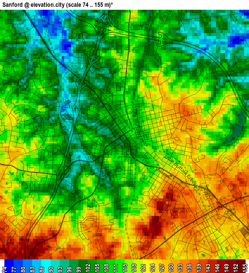
Below is the Elevation map of Sanford, which displays elevation range with different colors. Scale of the first map is from 74 to 155 m (243 to 509 ft) with average elevation of 113.4 meters (=372 ft) [note 1]
These maps also provides idea of topography and contour of this city, they are displayed at different zoom levels. More info about maps, scale and edge coordinates you can find below images.
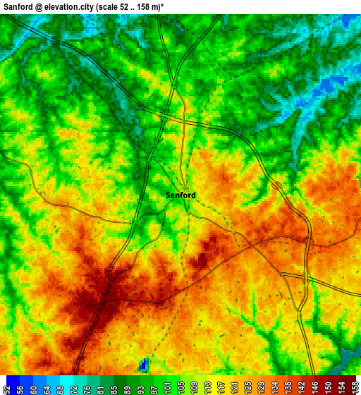
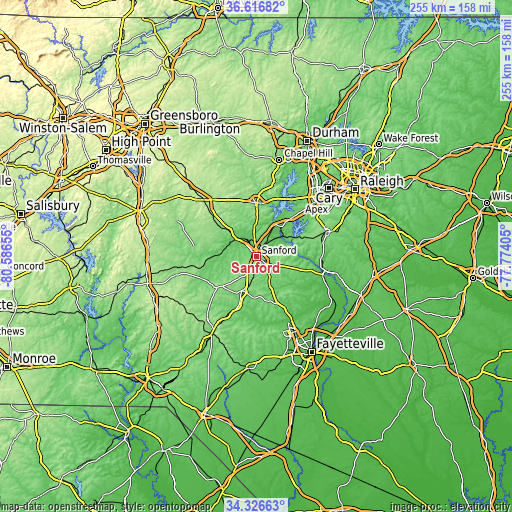
| \ | Map #1 | Map #2 | Topo.Map |
| Scale [m] | 74..155 m | 52..158 m | × |
| Scale [ft] | 243..509 ft | 171..518 ft | × |
| Average | 113.4 m = 372 ft | 109.3 m = 359 ft | × |
| Width | 7.96 km = 4.9 mi | 15.92 km = 9.9 mi | 254.6 km = 158.2 mi |
| Height | 7.96 km = 4.9 mi | 15.92 km = 9.9 mi | 254.6 km = 158.2 mi |
| ↑Max Latitude | 35.515658° | 35.551419° | 36.61682° |
| Latitude at center | 35.47988° | 35.47988° | 35.47988° |
| ↓Min Latitude | 35.444087° | 35.408277° | 34.32663° |
| ← Min Longitude | -79.224245° | -79.268191° | -80.58655° |
| Longitude center | -79.1803° | -79.1803° | -79.1803° |
| →Max Longitude | -79.136355° | -79.092409° | -77.77405° |
Nearby cities:
Cities around Sanford sort by population:
• Holly Springs elevation 138 m
36.7 km,  58°
58°
• Fuquay-Varina 119 m
36.3 km,  71°
71°
• Siler City 186 m
37.2 km,  316°
316°
• Farmville 87 m
10.7 km,  340°
340°
• Pittsboro 124 m
26.7 km,  0°
0°
• Lillington 63 m
34.2 km,  105°
105°
• Whispering Pines 115 m
30.4 km,  214°
214°
• Scotts Mill 106 m
38.4 km,  44°
44°
• Carthage 178 m
26.1 km,  235°
235°
• Fearrington Village 142 m
36.9 km,  12°
12°
• Broadway 145 m
11.8 km,  101°
101°
• Robbins 132 m
37.2 km,  262°
262°
Multilingual:
 En español:
Sanford elevación 111 m.
 En France:
Sanford élévation 111 m.


Sources and notes:
- [note 1] Map square and city borders are not equal. Map elevation data is calculated only from area inside that square.
- [src 1] Elevation data from geonames database provided with same terms of usage.
- [src 2] The elevation map of Sanford is generated using elevation data from NASA's 3 arcsec (90m) resolution SRTM data.
- [src 3] Base (background) map © OpenStreetMap contributors tiles are generated by Geofabrik and OpenTopoMap.
Copyright & License:
This Sanford Elevation Map is licensed under CC BY-SA. You may reuse any part from this page, if you give a proper credit by linking to this URL:
 More info on terms of use page.