Fearrington Village elevation
Fearrington Village (North Carolina, Chatham County), United States elevation is 142 meters and Fearrington Village elevation in feet is 466 ft above sea level [src 1]. Fearrington Village is a populated place (feature code) with elevation that is 137 meters (449 ft) smaller than average city elevation in United States.
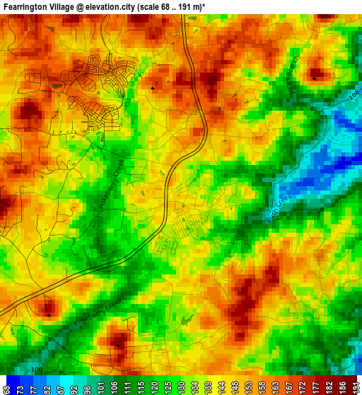
Below is the Elevation map of Fearrington Village, which displays elevation range with different colors. Scale of the first map is from 68 to 191 m (223 to 627 ft) with average elevation of 138.7 meters (=455 ft) [note 1]
These maps also provides idea of topography and contour of this city, they are displayed at different zoom levels. More info about maps, scale and edge coordinates you can find below images.
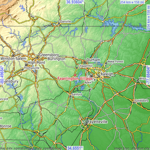
| \ | Map #1 | Topo.Map |
| Scale [m] | 68..191 m | × |
| Scale [ft] | 223..627 ft | × |
| Average | 138.7 m = 455 ft | × |
| Width | 7.93 km = 4.9 mi | 253.6 km = 157.6 mi |
| Height | 7.93 km = 4.9 mi | 253.6 km = 157.6 mi |
| ↑Max Latitude | 35.839393° | 36.93604° |
| Latitude at center | 35.80376° | 35.80376° |
| ↓Min Latitude | 35.768111° | 34.6551° |
| ← Min Longitude | -79.134235° | -80.49654° |
| Longitude center | -79.09029° | -79.09029° |
| →Max Longitude | -79.046345° | -77.68404° |
Nearby cities:
Cities around Fearrington Village sort by population:
• Durham elevation 121 m
27.3 km,  39°
39°
• Cary 152 m
27.9 km,  92°
92°
• Chapel Hill 149 m
12.6 km,  14°
14°
• Apex 153 m
23.1 km,  110°
110°
• Holly Springs 138 m
28.7 km,  126°
126°
• Morrisville 92 m
24 km,  84°
84°
• Carrboro 141 m
11.9 km, 6°
• Farmville 87 m
28.4 km,  204°
204°
• Pittsboro 124 m
12.2 km,  220°
220°
• Scotts Mill 106 m
20.5 km, 114°
• Green Level 103 m
17 km,  98°
98°
• Saxapahaw 140 m
26.3 km,  307°
307°
Multilingual:
 En español:
Fearrington Village elevación 142 m.
 En France:
Fearrington Village élévation 142 m.
 Auf Deutsch:
Fearrington Village höhe über dem Meeresspiegel ist 142 m.
 На русском:
Fearrington Village высота над уровнем моря 142 м
Sources and notes:
- [note 1] Map square and city borders are not equal. Map elevation data is calculated only from area inside that square.
- [src 1] Elevation data from geonames database provided with same terms of usage.
- [src 2] The elevation map of Fearrington Village is generated using elevation data from NASA's 3 arcsec (90m) resolution SRTM data.
- [src 3] Base (background) map © OpenStreetMap contributors tiles are generated by Geofabrik and OpenTopoMap.
Copyright & License:
This Fearrington Village Elevation Map is licensed under CC BY-SA. You may reuse any part from this page, if you give a proper credit by linking to this URL:
 More info on terms of use page.