Sainte Genevieve elevation
Sainte Genevieve (Missouri, Sainte Genevieve County), United States elevation is 117 meters and Sainte Genevieve elevation in feet is 384 ft above sea level [src 1]. Sainte Genevieve is a populated place (feature code) with elevation that is 162 meters (531 ft) smaller than average city elevation in United States.
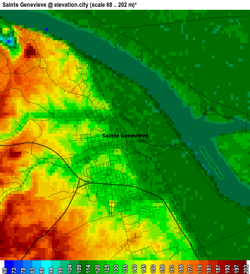
Below is the Elevation map of Sainte Genevieve, which displays elevation range with different colors. Scale of the first map is from 68 to 202 m (223 to 663 ft) with average elevation of 130.1 meters (=427 ft) [note 1]
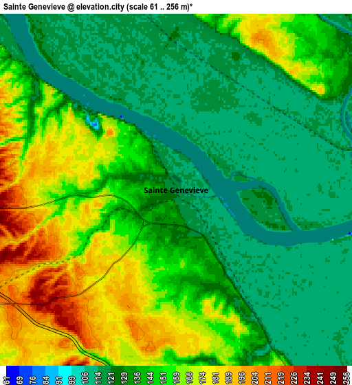
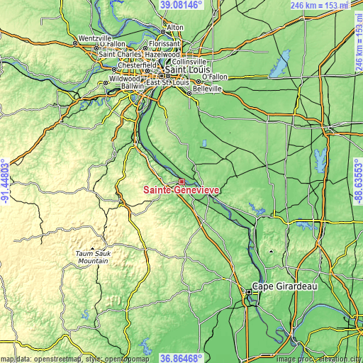
These maps also provides idea of topography and contour of this city, they are displayed at different zoom levels. More info about maps, scale and edge coordinates you can find below images.
| \ | Map #1 | Map #2 | Topo.Map |
| Scale [m] | 68..202 m | 61..256 m | × |
| Scale [ft] | 223..663 ft | 200..840 ft | × |
| Average | 130.1 m = 427 ft | 141.5 m = 464 ft | × |
| Width | 7.7 km = 4.8 mi | 15.41 km = 9.6 mi | 246.5 km = 153.2 mi |
| Height | 7.7 km = 4.8 mi | 15.41 km = 9.6 mi | 246.5 km = 153.2 mi |
| ↑Max Latitude | 38.01607° | 38.050684° | 39.08146° |
| Latitude at center | 37.98144° | 37.98144° | 37.98144° |
| ↓Min Latitude | 37.946794° | 37.912131° | 36.86468° |
| ← Min Longitude | -90.085725° | -90.129671° | -91.44803° |
| Longitude center | -90.04178° | -90.04178° | -90.04178° |
| →Max Longitude | -89.997835° | -89.953889° | -88.63553° |
Nearby cities:
Cities around Sainte Genevieve sort by population:
• Farmington elevation 284 m
40.1 km,  236°
236°
• Festus 132 m
40.8 km,  310°
310°
• Waterloo 216 m
40.5 km,  346°
346°
• Chester 201 m
20.7 km,  111°
111°
• Perryville 177 m
32.7 km,  151°
151°
• Crystal City 134 m
39.8 km, 312°
• Sparta 160 m
33.7 km,  62°
62°
• Red Bud 143 m
25.9 km,  9°
9°
• Steeleville 126 m
33.7 km,  85°
85°
• New Athens 123 m
41 km,  20°
20°
• Marissa 140 m
39.3 km,  40°
40°
• Valmeyer 225 m
41.5 km,  330°
330°
Multilingual:
 En español:
Sainte Genevieve elevación 117 m.
 En France:
Sainte Genevieve élévation 117 m.
 Auf Deutsch:
Sainte Genevieve höhe über dem Meeresspiegel ist 117 m.

Sources and notes:
- [note 1] Map square and city borders are not equal. Map elevation data is calculated only from area inside that square.
- [src 1] Elevation data from geonames database provided with same terms of usage.
- [src 2] The elevation map of Sainte Genevieve is generated using elevation data from NASA's 3 arcsec (90m) resolution SRTM data.
- [src 3] Base (background) map © OpenStreetMap contributors tiles are generated by Geofabrik and OpenTopoMap.
Copyright & License:
This Sainte Genevieve Elevation Map is licensed under CC BY-SA. You may reuse any part from this page, if you give a proper credit by linking to this URL:
 More info on terms of use page.