Festus elevation
Festus (Missouri, Jefferson County), United States elevation is 132 meters and Festus elevation in feet is 433 ft above sea level [src 1]. Festus is a populated place (feature code) with elevation that is 147 meters (482 ft) smaller than average city elevation in United States.
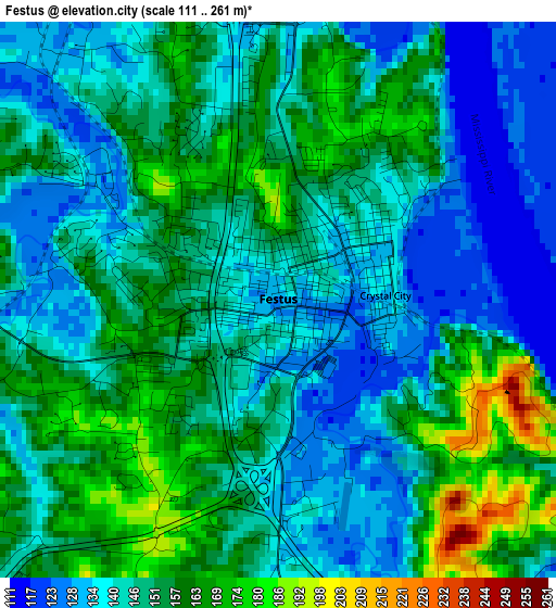
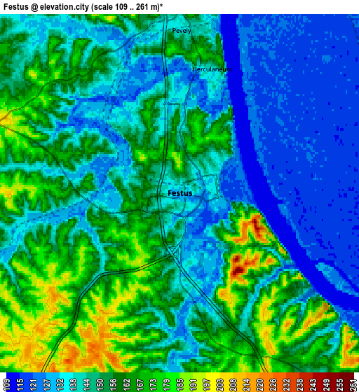
Below is the Elevation map of Festus, which displays elevation range with different colors. Scale of the first map is from 111 to 261 m (364 to 856 ft) with average elevation of 148.1 meters (=486 ft) [note 1]
These maps also provides idea of topography and contour of this city, they are displayed at different zoom levels. More info about maps, scale and edge coordinates you can find below images.
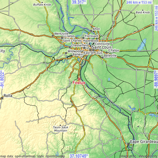
| \ | Map #1 | Map #2 | Topo.Map |
| Scale [m] | 111..261 m | 109..261 m | × |
| Scale [ft] | 364..856 ft | 358..856 ft | × |
| Average | 148.1 m = 486 ft | 148.6 m = 488 ft | × |
| Width | 7.68 km = 4.8 mi | 15.36 km = 9.5 mi | 245.7 km = 152.7 mi |
| Height | 7.68 km = 4.8 mi | 15.36 km = 9.5 mi | 245.7 km = 152.7 mi |
| ↑Max Latitude | 38.255127° | 38.289627° | 39.317° |
| Latitude at center | 38.22061° | 38.22061° | 38.22061° |
| ↓Min Latitude | 38.186077° | 38.151527° | 37.10745° |
| ← Min Longitude | -90.439895° | -90.483841° | -91.8022° |
| Longitude center | -90.39595° | -90.39595° | -90.39595° |
| →Max Longitude | -90.352005° | -90.308059° | -88.9897° |
Nearby cities:
Cities around Festus sort by population:
• Arnold elevation 178 m
23.7 km,  3°
3°
• Waterloo 216 m
25 km,  59°
59°
• De Soto 166 m
16.6 km,  237°
237°
• Barnhart 136 m
13.7 km, 0°
• Pevely 138 m
7 km, 0°
• Crystal City 134 m
1.5 km,  87°
87°
• Imperial 133 m
16.7 km,  5°
5°
• Herculaneum 136 m
5.5 km, 14°
• Hillsboro 238 m
14.6 km,  275°
275°
• Riverside 128 m
7.5 km, 10°
• Cedar Hill 176 m
26 km,  304°
304°
• Valmeyer 225 m
14.1 km,  47°
47°
Multilingual:
 En español:
Festus elevación 132 m.
 En France:
Festus élévation 132 m.


Sources and notes:
- [note 1] Map square and city borders are not equal. Map elevation data is calculated only from area inside that square.
- [src 1] Elevation data from geonames database provided with same terms of usage.
- [src 2] The elevation map of Festus is generated using elevation data from NASA's 3 arcsec (90m) resolution SRTM data.
- [src 3] Base (background) map © OpenStreetMap contributors tiles are generated by Geofabrik and OpenTopoMap.
Copyright & License:
This Festus Elevation Map is licensed under CC BY-SA. You may reuse any part from this page, if you give a proper credit by linking to this URL:
 More info on terms of use page.