Cedar Hill elevation
Cedar Hill (Missouri, Jefferson County), United States elevation is 176 meters and Cedar Hill elevation in feet is 577 ft above sea level [src 1]. Cedar Hill is a populated place (feature code) with elevation that is 103 meters (338 ft) smaller than average city elevation in United States.
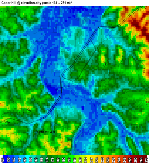
Below is the Elevation map of Cedar Hill, which displays elevation range with different colors. Scale of the first map is from 131 to 271 m (430 to 889 ft) with average elevation of 171.5 meters (=563 ft) [note 1]
These maps also provides idea of topography and contour of this city, they are displayed at different zoom levels. More info about maps, scale and edge coordinates you can find below images.
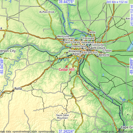
| \ | Map #1 | Topo.Map |
| Scale [m] | 131..271 m | × |
| Scale [ft] | 430..889 ft | × |
| Average | 171.5 m = 563 ft | × |
| Width | 7.66 km = 4.8 mi | 245.2 km = 152.4 mi |
| Height | 7.66 km = 4.8 mi | 245.2 km = 152.4 mi |
| ↑Max Latitude | 38.387844° | 39.44775° |
| Latitude at center | 38.35339° | 38.35339° |
| ↓Min Latitude | 38.31892° | 37.24224° |
| ← Min Longitude | -90.685185° | -92.04749° |
| Longitude center | -90.64124° | -90.64124° |
| →Max Longitude | -90.597295° | -89.23499° |
Nearby cities:
Cities around Cedar Hill sort by population:
• Eureka elevation 140 m
16.6 km,  4°
4°
• Murphy 173 m
20.3 km,  41°
41°
• Pacific 141 m
16.8 km,  328°
328°
• Barnhart 136 m
21.6 km,  92°
92°
• Pevely 138 m
22.8 km,  109°
109°
• Imperial 133 m
23 km, 85°
• High Ridge 279 m
14.9 km, 37°
• Hillsboro 238 m
15.1 km,  153°
153°
• Riverside 128 m
24 km, 108°
• Byrnes Mill 149 m
10.7 km,  28°
28°
• Gray Summit 204 m
21.5 km,  314°
314°
• LaBarque Creek 183 m
7.8 km, 334°
Multilingual:
 En español:
Cedar Hill elevación 176 m.
 En France:
Cedar Hill élévation 176 m.
 Auf Deutsch:
Cedar Hill höhe über dem Meeresspiegel ist 176 m.

Sources and notes:
- [note 1] Map square and city borders are not equal. Map elevation data is calculated only from area inside that square.
- [src 1] Elevation data from geonames database provided with same terms of usage.
- [src 2] The elevation map of Cedar Hill is generated using elevation data from NASA's 3 arcsec (90m) resolution SRTM data.
- [src 3] Base (background) map © OpenStreetMap contributors tiles are generated by Geofabrik and OpenTopoMap.
Copyright & License:
This Cedar Hill Elevation Map is licensed under CC BY-SA. You may reuse any part from this page, if you give a proper credit by linking to this URL:
 More info on terms of use page.