Osceola elevation
Osceola (Missouri, Saint Clair County), United States elevation is 234 meters and Osceola elevation in feet is 768 ft above sea level [src 1]. Osceola is a seat of a second-order administrative division (feature code) with elevation that is 45 meters (148 ft) smaller than average city elevation in United States.
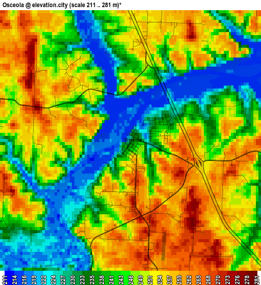
Below is the Elevation map of Osceola, which displays elevation range with different colors. Scale of the first map is from 211 to 281 m (692 to 922 ft) with average elevation of 245.6 meters (=806 ft) [note 1]
These maps also provides idea of topography and contour of this city, they are displayed at different zoom levels. More info about maps, scale and edge coordinates you can find below images.
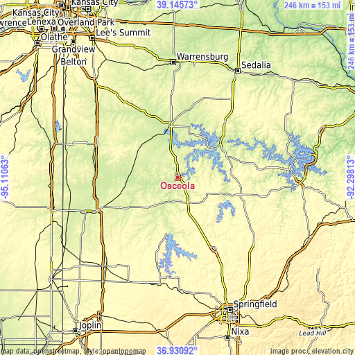
| \ | Map #1 | Topo.Map |
| Scale [m] | 211..281 m | × |
| Scale [ft] | 692..922 ft | × |
| Average | 245.6 m = 806 ft | × |
| Width | 7.7 km = 4.8 mi | 246.3 km = 153 mi |
| Height | 7.7 km = 4.8 mi | 246.3 km = 153 mi |
| ↑Max Latitude | 38.081299° | 39.14573° |
| Latitude at center | 38.0467° | 38.0467° |
| ↓Min Latitude | 38.012085° | 36.93092° |
| ← Min Longitude | -93.748325° | -95.11063° |
| Longitude center | -93.70438° | -93.70438° |
| →Max Longitude | -93.660435° | -92.29813° |
Nearby cities:
Cities around Osceola sort by population:
• Bolivar elevation 326 m
54.6 km,  151°
151°
• Clinton 247 m
36.4 km,  349°
349°
• Butler 269 m
59.6 km,  293°
293°
• El Dorado Springs 261 m
33.6 km,  235°
235°
• Windsor 284 m
56.3 km,  16°
16°
• Warsaw 223 m
35.7 km,  52°
52°
• Stockton 290 m
39.5 km,  191°
191°
• Rich Hill 244 m
57.7 km,  275°
275°
• Lincoln 296 m
50.1 km,  40°
40°
• Appleton City 267 m
32.6 km,  299°
299°
• Humansville 293 m
30.2 km,  158°
158°
• Hermitage 251 m
36 km,  108°
108°
Multilingual:
 En español:
Osceola elevación 234 m.
 En France:
Osceola élévation 234 m.


Sources and notes:
- [note 1] Map square and city borders are not equal. Map elevation data is calculated only from area inside that square.
- [src 1] Elevation data from geonames database provided with same terms of usage.
- [src 2] The elevation map of Osceola is generated using elevation data from NASA's 3 arcsec (90m) resolution SRTM data.
- [src 3] Base (background) map © OpenStreetMap contributors tiles are generated by Geofabrik and OpenTopoMap.
Copyright & License:
This Osceola Elevation Map is licensed under CC BY-SA. You may reuse any part from this page, if you give a proper credit by linking to this URL:
 More info on terms of use page.