Warsaw elevation
Warsaw (Missouri, Benton County), United States elevation is 223 meters and Warsaw elevation in feet is 732 ft above sea level [src 1]. Warsaw is a seat of a second-order administrative division (feature code) with elevation that is 56 meters (184 ft) smaller than average city elevation in United States.
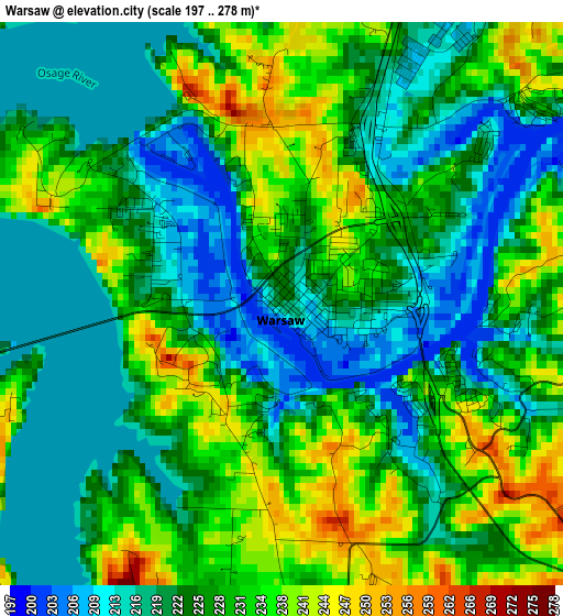
Below is the Elevation map of Warsaw, which displays elevation range with different colors. Scale of the first map is from 197 to 278 m (646 to 912 ft) with average elevation of 225.9 meters (=741 ft) [note 1]
These maps also provides idea of topography and contour of this city, they are displayed at different zoom levels. More info about maps, scale and edge coordinates you can find below images.
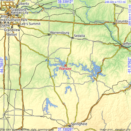
| \ | Map #1 | Topo.Map |
| Scale [m] | 197..278 m | × |
| Scale [ft] | 646..912 ft | × |
| Average | 225.9 m = 741 ft | × |
| Width | 7.68 km = 4.8 mi | 245.6 km = 152.6 mi |
| Height | 7.68 km = 4.8 mi | 245.6 km = 152.6 mi |
| ↑Max Latitude | 38.277586° | 39.33912° |
| Latitude at center | 38.24308° | 38.24308° |
| ↓Min Latitude | 38.208558° | 37.13026° |
| ← Min Longitude | -93.425815° | -94.78812° |
| Longitude center | -93.38187° | -93.38187° |
| →Max Longitude | -93.337925° | -91.97562° |
Nearby cities:
Cities around Warsaw sort by population:
• Sedalia elevation 282 m
53 km,  14°
14°
• Clinton 247 m
37.3 km,  291°
291°
• Riverview 256 m
27.5 km,  82°
82°
• Windsor 284 m
34.4 km,  339°
339°
• Whiteman Air Force Base 260 m
56.3 km, 344°
• Versailles 320 m
51.6 km,  66°
66°
• Lincoln 296 m
16.9 km, 14°
• Cole Camp 325 m
28.7 km,  32°
32°
• Stover 331 m
40.5 km,  57°
57°
• Humansville 293 m
52.8 km,  199°
199°
• Osceola 234 m
35.7 km,  232°
232°
• Hermitage 251 m
34 km,  170°
170°
Multilingual:
 En español:
Warsaw elevación 223 m.
 En France:
Warsaw élévation 223 m.


Sources and notes:
- [note 1] Map square and city borders are not equal. Map elevation data is calculated only from area inside that square.
- [src 1] Elevation data from geonames database provided with same terms of usage.
- [src 2] The elevation map of Warsaw is generated using elevation data from NASA's 3 arcsec (90m) resolution SRTM data.
- [src 3] Base (background) map © OpenStreetMap contributors tiles are generated by Geofabrik and OpenTopoMap.
Copyright & License:
This Warsaw Elevation Map is licensed under CC BY-SA. You may reuse any part from this page, if you give a proper credit by linking to this URL:
 More info on terms of use page.