Versailles elevation
Versailles (Missouri, Morgan County), United States elevation is 320 meters and Versailles elevation in feet is 1050 ft above sea level [src 1]. Versailles is a seat of a second-order administrative division (feature code) with elevation that is 41 meters (135 ft) bigger than average city elevation in United States.
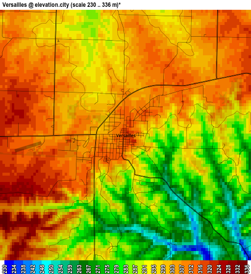
Below is the Elevation map of Versailles, which displays elevation range with different colors. Scale of the first map is from 230 to 336 m (755 to 1102 ft) with average elevation of 297.3 meters (=975 ft) [note 1]
These maps also provides idea of topography and contour of this city, they are displayed at different zoom levels. More info about maps, scale and edge coordinates you can find below images.
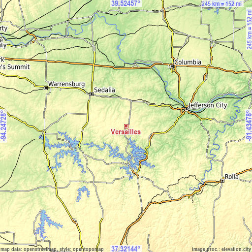
| \ | Map #1 | Topo.Map |
| Scale [m] | 230..336 m | × |
| Scale [ft] | 755..1102 ft | × |
| Average | 297.3 m = 975 ft | × |
| Width | 7.66 km = 4.8 mi | 245 km = 152.2 mi |
| Height | 7.66 km = 4.8 mi | 245 km = 152.2 mi |
| ↑Max Latitude | 38.465826° | 39.52457° |
| Latitude at center | 38.43141° | 38.43141° |
| ↓Min Latitude | 38.396977° | 37.32144° |
| ← Min Longitude | -92.884975° | -94.24728° |
| Longitude center | -92.84103° | -92.84103° |
| →Max Longitude | -92.797085° | -91.43478° |
Nearby cities:
Cities around Versailles sort by population:
• Sedalia elevation 282 m
45.3 km,  312°
312°
• Eldon 286 m
24.4 km,  112°
112°
• Osage Beach 236 m
37.4 km,  153°
153°
• California 274 m
32.3 km,  47°
47°
• Tipton 286 m
25.5 km,  12°
12°
• Riverview 256 m
26.4 km,  229°
229°
• Four Seasons 234 m
28.3 km,  156°
156°
• Lake Ozark 230 m
31.3 km, 145°
• Lincoln 296 m
43.2 km,  264°
264°
• Cole Camp 325 m
31.7 km,  275°
275°
• Stover 331 m
13.2 km,  274°
274°
• Tuscumbia 184 m
40 km,  123°
123°
Multilingual:
 En español:
Versailles elevación 320 m.
 En France:
Versailles élévation 320 m.
 Auf Deutsch:
Versailles höhe über dem Meeresspiegel ist 320 m.

Sources and notes:
- [note 1] Map square and city borders are not equal. Map elevation data is calculated only from area inside that square.
- [src 1] Elevation data from geonames database provided with same terms of usage.
- [src 2] The elevation map of Versailles is generated using elevation data from NASA's 3 arcsec (90m) resolution SRTM data.
- [src 3] Base (background) map © OpenStreetMap contributors tiles are generated by Geofabrik and OpenTopoMap.
Copyright & License:
This Versailles Elevation Map is licensed under CC BY-SA. You may reuse any part from this page, if you give a proper credit by linking to this URL:
 More info on terms of use page.