Tipton elevation
Tipton (Missouri, Moniteau County), United States elevation is 286 meters and Tipton elevation in feet is 938 ft above sea level [src 1]. Tipton is a populated place (feature code) with elevation that is 7 meters (23 ft) bigger than average city elevation in United States.
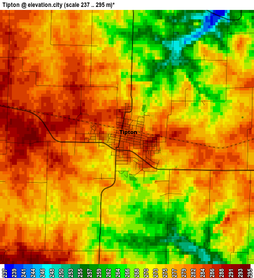
Below is the Elevation map of Tipton, which displays elevation range with different colors. Scale of the first map is from 237 to 295 m (778 to 968 ft) with average elevation of 275 meters (=902 ft) [note 1]
These maps also provides idea of topography and contour of this city, they are displayed at different zoom levels. More info about maps, scale and edge coordinates you can find below images.
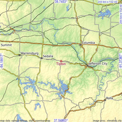
| \ | Map #1 | Topo.Map |
| Scale [m] | 237..295 m | × |
| Scale [ft] | 778..968 ft | × |
| Average | 275 m = 902 ft | × |
| Width | 7.63 km = 4.7 mi | 244.2 km = 151.7 mi |
| Height | 7.63 km = 4.7 mi | 244.2 km = 151.7 mi |
| ↑Max Latitude | 38.689889° | 39.7453° |
| Latitude at center | 38.65558° | 38.65558° |
| ↓Min Latitude | 38.621254° | 37.54903° |
| ← Min Longitude | -92.823865° | -94.18617° |
| Longitude center | -92.77992° | -92.77992° |
| →Max Longitude | -92.735975° | -91.37367° |
Nearby cities:
Cities around Tipton sort by population:
• Columbia elevation 219 m
50.8 km,  49°
49°
• Sedalia 282 m
39.3 km,  277°
277°
• Boonville 210 m
35.5 km,  5°
5°
• Eldon 286 m
38.3 km,  153°
153°
• California 274 m
18.8 km,  99°
99°
• Ashland 277 m
47.2 km,  73°
73°
• Riverview 256 m
49.2 km,  210°
210°
• Versailles 320 m
25.5 km,  192°
192°
• Saint Martins 236 m
39.1 km, 100°
• Cole Camp 325 m
42.7 km,  239°
239°
• New Franklin 202 m
40.4 km, 5°
• Stover 331 m
30.2 km,  217°
217°
Multilingual:
 En español:
Tipton elevación 286 m.
 En France:
Tipton élévation 286 m.


Sources and notes:
- [note 1] Map square and city borders are not equal. Map elevation data is calculated only from area inside that square.
- [src 1] Elevation data from geonames database provided with same terms of usage.
- [src 2] The elevation map of Tipton is generated using elevation data from NASA's 3 arcsec (90m) resolution SRTM data.
- [src 3] Base (background) map © OpenStreetMap contributors tiles are generated by Geofabrik and OpenTopoMap.
Copyright & License:
This Tipton Elevation Map is licensed under CC BY-SA. You may reuse any part from this page, if you give a proper credit by linking to this URL:
 More info on terms of use page.