New Franklin elevation
New Franklin (Missouri, Howard County), United States elevation is 202 meters and New Franklin elevation in feet is 663 ft above sea level [src 1]. New Franklin is a populated place (feature code) with elevation that is 77 meters (253 ft) smaller than average city elevation in United States.
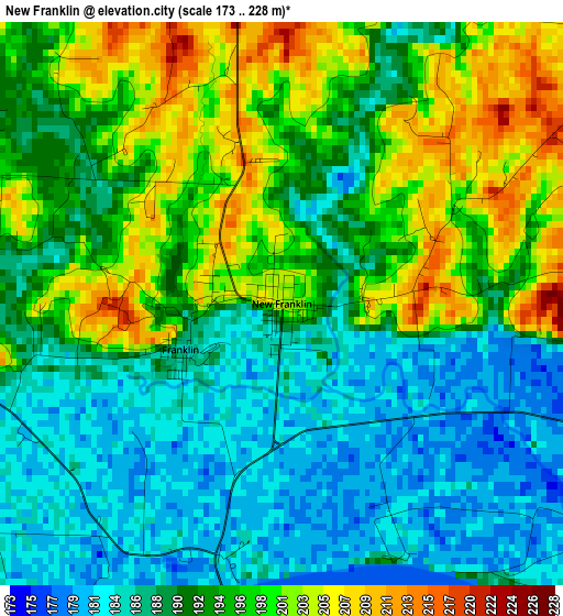
Below is the Elevation map of New Franklin, which displays elevation range with different colors. Scale of the first map is from 173 to 228 m (568 to 748 ft) with average elevation of 192.6 meters (=632 ft) [note 1]
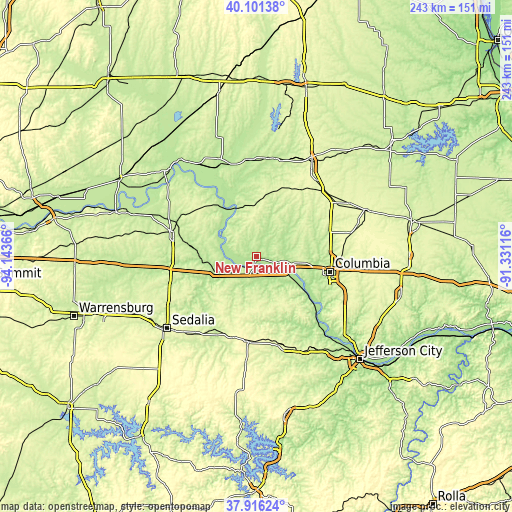
These maps also provides idea of topography and contour of this city, they are displayed at different zoom levels. More info about maps, scale and edge coordinates you can find below images.
| \ | Map #1 | Topo.Map |
| Scale [m] | 173..228 m | × |
| Scale [ft] | 568..748 ft | × |
| Average | 192.6 m = 632 ft | × |
| Width | 7.59 km = 4.7 mi | 243 km = 151 mi |
| Height | 7.59 km = 4.7 mi | 243 km = 151 mi |
| ↑Max Latitude | 39.051385° | 40.10138° |
| Latitude at center | 39.01725° | 39.01725° |
| ↓Min Latitude | 38.983098° | 37.91624° |
| ← Min Longitude | -92.781355° | -94.14366° |
| Longitude center | -92.73741° | -92.73741° |
| →Max Longitude | -92.693465° | -91.33116° |
Nearby cities:
Cities around New Franklin sort by population:
• Columbia elevation 219 m
35.6 km,  101°
101°
• Marshall 239 m
41.4 km,  286°
286°
• Boonville 210 m
4.9 km,  185°
185°
• California 274 m
45.8 km,  161°
161°
• Ashland 277 m
49.6 km,  123°
123°
• Tipton 286 m
40.4 km, 185°
• Fayette 217 m
15 km,  17°
17°
• Slater 266 m
36.3 km,  307°
307°
• Salisbury 229 m
45.6 km,  353°
353°
• Hallsville 278 m
46 km,  76°
76°
• Glasgow 203 m
25.2 km,  338°
338°
• Keytesville 221 m
49.5 km, 339°
Multilingual:
 En español:
New Franklin elevación 202 m.
 En France:
New Franklin élévation 202 m.
 Auf Deutsch:
New Franklin höhe über dem Meeresspiegel ist 202 m.

Sources and notes:
- [note 1] Map square and city borders are not equal. Map elevation data is calculated only from area inside that square.
- [src 1] Elevation data from geonames database provided with same terms of usage.
- [src 2] The elevation map of New Franklin is generated using elevation data from NASA's 3 arcsec (90m) resolution SRTM data.
- [src 3] Base (background) map © OpenStreetMap contributors tiles are generated by Geofabrik and OpenTopoMap.
Copyright & License:
This New Franklin Elevation Map is licensed under CC BY-SA. You may reuse any part from this page, if you give a proper credit by linking to this URL:
 More info on terms of use page.