Bolivar elevation
Bolivar (Missouri, Polk County), United States elevation is 326 meters and Bolivar elevation in feet is 1070 ft above sea level [src 1]. Bolivar is a seat of a second-order administrative division (feature code) with elevation that is 47 meters (154 ft) bigger than average city elevation in United States.
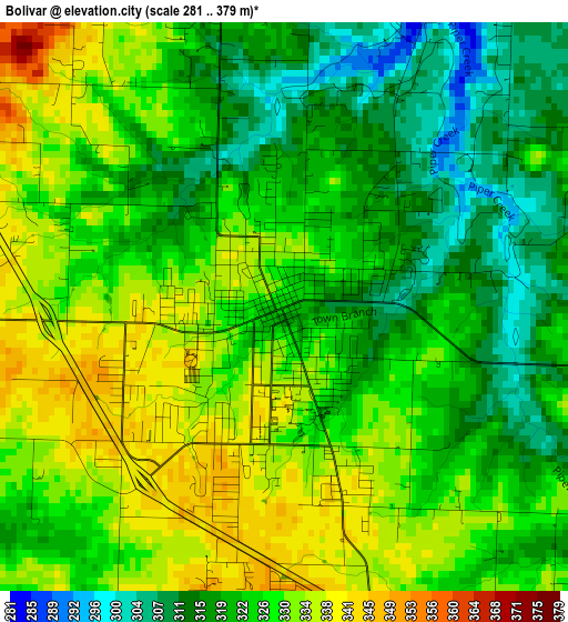
Below is the Elevation map of Bolivar, which displays elevation range with different colors. Scale of the first map is from 281 to 379 m (922 to 1243 ft) with average elevation of 324.9 meters (=1066 ft) [note 1]
These maps also provides idea of topography and contour of this city, they are displayed at different zoom levels. More info about maps, scale and edge coordinates you can find below images.
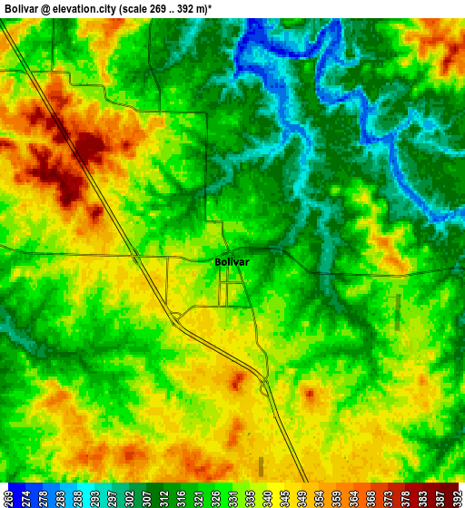
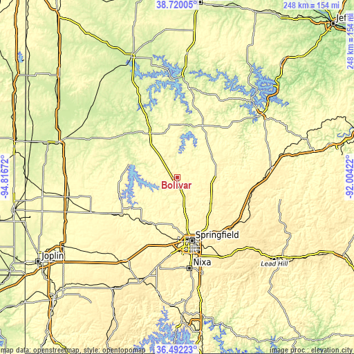
| \ | Map #1 | Map #2 | Topo.Map |
| Scale [m] | 281..379 m | 269..392 m | × |
| Scale [ft] | 922..1243 ft | 883..1286 ft | × |
| Average | 324.9 m = 1066 ft | 328.1 m = 1076 ft | × |
| Width | 7.74 km = 4.8 mi | 15.48 km = 9.6 mi | 247.7 km = 153.9 mi |
| Height | 7.74 km = 4.8 mi | 15.48 km = 9.6 mi | 247.7 km = 153.9 mi |
| ↑Max Latitude | 37.649282° | 37.684069° | 38.72005° |
| Latitude at center | 37.61448° | 37.61448° | 37.61448° |
| ↓Min Latitude | 37.579661° | 37.544826° | 36.49223° |
| ← Min Longitude | -93.454415° | -93.498361° | -94.81672° |
| Longitude center | -93.41047° | -93.41047° | -93.41047° |
| →Max Longitude | -93.366525° | -93.322579° | -92.00422° |
Nearby cities:
Cities around Bolivar sort by population:
• Springfield elevation 399 m
45.5 km,  167°
167°
• Marshfield 456 m
54 km,  124°
124°
• Willard 380 m
34.4 km,  182°
182°
• Buffalo 365 m
28.2 km,  83°
83°
• Strafford 455 m
46.4 km,  146°
146°
• Stockton 290 m
35.2 km,  285°
285°
• Ash Grove 325 m
36.7 km,  204°
204°
• Fair Grove 372 m
34.3 km,  138°
138°
• Greenfield 339 m
44 km,  239°
239°
• Humansville 293 m
24.9 km,  323°
323°
• Osceola 234 m
54.6 km,  331°
331°
• Hermitage 251 m
37.3 km,  12°
12°
Multilingual:
 En español:
Bolivar elevación 326 m.
 En France:
Bolivar élévation 326 m.


Sources and notes:
- [note 1] Map square and city borders are not equal. Map elevation data is calculated only from area inside that square.
- [src 1] Elevation data from geonames database provided with same terms of usage.
- [src 2] The elevation map of Bolivar is generated using elevation data from NASA's 3 arcsec (90m) resolution SRTM data.
- [src 3] Base (background) map © OpenStreetMap contributors tiles are generated by Geofabrik and OpenTopoMap.
Copyright & License:
This Bolivar Elevation Map is licensed under CC BY-SA. You may reuse any part from this page, if you give a proper credit by linking to this URL:
 More info on terms of use page.