Willard elevation
Willard (Missouri, Greene County), United States elevation is 380 meters and Willard elevation in feet is 1247 ft above sea level [src 1]. Willard is a populated place (feature code) with elevation that is 101 meters (331 ft) bigger than average city elevation in United States.
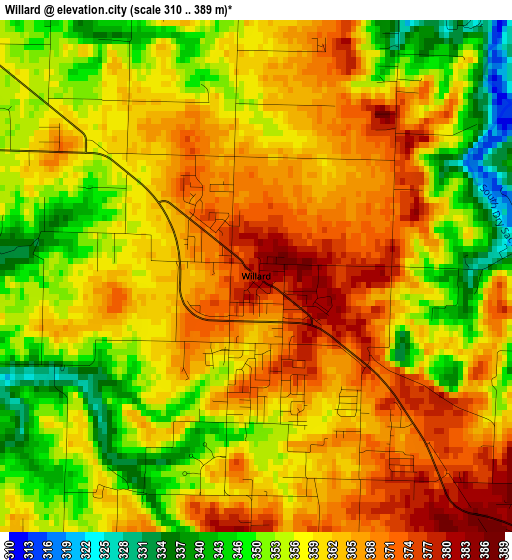
Below is the Elevation map of Willard, which displays elevation range with different colors. Scale of the first map is from 310 to 389 m (1017 to 1276 ft) with average elevation of 359.1 meters (=1178 ft) [note 1]
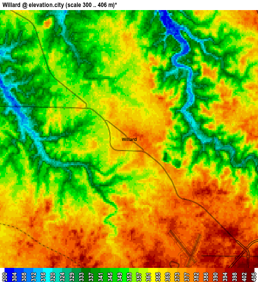
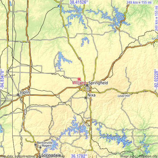
These maps also provides idea of topography and contour of this city, they are displayed at different zoom levels. More info about maps, scale and edge coordinates you can find below images.
| \ | Map #1 | Map #2 | Topo.Map |
| Scale [m] | 310..389 m | 300..406 m | × |
| Scale [ft] | 1017..1276 ft | 984..1332 ft | × |
| Average | 359.1 m = 1178 ft | 359.6 m = 1180 ft | × |
| Width | 7.77 km = 4.8 mi | 15.55 km = 9.7 mi | 248.7 km = 154.5 mi |
| Height | 7.77 km = 4.8 mi | 15.55 km = 9.7 mi | 248.7 km = 154.5 mi |
| ↑Max Latitude | 37.339997° | 37.374927° | 38.41526° |
| Latitude at center | 37.30505° | 37.30505° | 37.30505° |
| ↓Min Latitude | 37.270087° | 37.235108° | 36.1782° |
| ← Min Longitude | -93.472475° | -93.516421° | -94.83478° |
| Longitude center | -93.42853° | -93.42853° | -93.42853° |
| →Max Longitude | -93.384585° | -93.340639° | -92.02228° |
Nearby cities:
Cities around Willard sort by population:
• Springfield elevation 399 m
15.2 km,  130°
130°
• Nixa 398 m
31.4 km,  157°
157°
• Ozark 360 m
37.2 km,  148°
148°
• Republic 402 m
21.1 km,  192°
192°
• Bolivar 326 m
34.4 km,  2°
2°
• Battlefield 391 m
21.7 km,  166°
166°
• Clever 430 m
30.8 km, 187°
• Strafford 455 m
27.8 km,  98°
98°
• Marionville 419 m
38.3 km,  208°
208°
• Ash Grove 325 m
13.9 km,  274°
274°
• Fair Grove 372 m
26 km,  70°
70°
• Billings 421 m
28.6 km,  202°
202°
Multilingual:
 En español:
Willard elevación 380 m.
 En France:
Willard élévation 380 m.


Sources and notes:
- [note 1] Map square and city borders are not equal. Map elevation data is calculated only from area inside that square.
- [src 1] Elevation data from geonames database provided with same terms of usage.
- [src 2] The elevation map of Willard is generated using elevation data from NASA's 3 arcsec (90m) resolution SRTM data.
- [src 3] Base (background) map © OpenStreetMap contributors tiles are generated by Geofabrik and OpenTopoMap.
Copyright & License:
This Willard Elevation Map is licensed under CC BY-SA. You may reuse any part from this page, if you give a proper credit by linking to this URL:
 More info on terms of use page.