Nixa elevation
Nixa (Missouri, Christian County), United States elevation is 398 meters and Nixa elevation in feet is 1306 ft above sea level [src 1]. Nixa is a populated place (feature code) with elevation that is 119 meters (390 ft) bigger than average city elevation in United States.
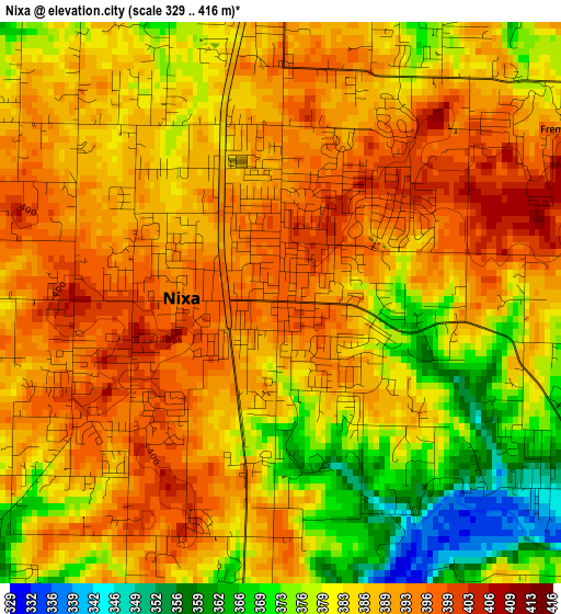
Below is the Elevation map of Nixa, which displays elevation range with different colors. Scale of the first map is from 329 to 416 m (1079 to 1365 ft) with average elevation of 385.4 meters (=1264 ft) [note 1]
These maps also provides idea of topography and contour of this city, they are displayed at different zoom levels. More info about maps, scale and edge coordinates you can find below images.
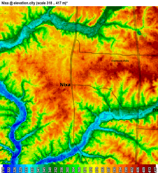
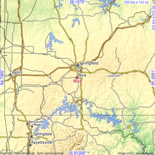
| \ | Map #1 | Map #2 | Topo.Map |
| Scale [m] | 329..416 m | 318..417 m | × |
| Scale [ft] | 1079..1365 ft | 1043..1368 ft | × |
| Average | 385.4 m = 1264 ft | 375.2 m = 1231 ft | × |
| Width | 7.8 km = 4.8 mi | 15.6 km = 9.7 mi | 249.6 km = 155.1 mi |
| Height | 7.8 km = 4.8 mi | 15.6 km = 9.7 mi | 249.6 km = 155.1 mi |
| ↑Max Latitude | 37.078458° | 37.11351° | 38.1575° |
| Latitude at center | 37.04339° | 37.04339° | 37.04339° |
| ↓Min Latitude | 37.008306° | 36.973205° | 35.91268° |
| ← Min Longitude | -93.338295° | -93.382241° | -94.7006° |
| Longitude center | -93.29435° | -93.29435° | -93.29435° |
| →Max Longitude | -93.250405° | -93.206459° | -91.8881° |
Nearby cities:
Cities around Nixa sort by population:
• Springfield elevation 399 m
19.1 km,  358°
358°
• Ozark 360 m
8.2 km,  107°
107°
• Republic 402 m
18.6 km,  297°
297°
• Battlefield 391 m
10.5 km,  320°
320°
• Rogersville 447 m
22.7 km,  68°
68°
• Clever 430 m
15.9 km,  264°
264°
• Strafford 455 m
29.5 km,  32°
32°
• Marionville 419 m
30.8 km, 261°
• Sparta 432 m
19.5 km,  103°
103°
• Crane 351 m
29 km,  238°
238°
• Billings 421 m
23 km,  276°
276°
• Galena 310 m
30.6 km,  210°
210°
Multilingual:
 En español:
Nixa elevación 398 m.
 En France:
Nixa élévation 398 m.


Sources and notes:
- [note 1] Map square and city borders are not equal. Map elevation data is calculated only from area inside that square.
- [src 1] Elevation data from geonames database provided with same terms of usage.
- [src 2] The elevation map of Nixa is generated using elevation data from NASA's 3 arcsec (90m) resolution SRTM data.
- [src 3] Base (background) map © OpenStreetMap contributors tiles are generated by Geofabrik and OpenTopoMap.
Copyright & License:
This Nixa Elevation Map is licensed under CC BY-SA. You may reuse any part from this page, if you give a proper credit by linking to this URL:
 More info on terms of use page.