Springfield elevation
Springfield (Missouri, Greene County), United States elevation is 399 meters and Springfield elevation in feet is 1309 ft above sea level [src 1]. Springfield is a seat of a second-order administrative division (feature code) with elevation that is 120 meters (394 ft) bigger than average city elevation in United States.
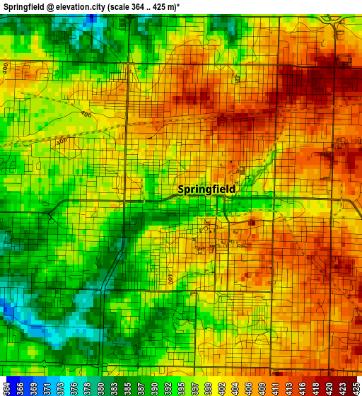
Below is the Elevation map of Springfield, which displays elevation range with different colors. Scale of the first map is from 364 to 425 m (1194 to 1394 ft) with average elevation of 399.7 meters (=1311 ft) [note 1]
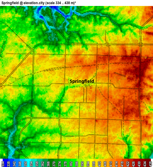
These maps also provides idea of topography and contour of this city, they are displayed at different zoom levels. More info about maps, scale and edge coordinates you can find below images.
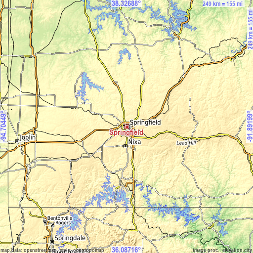
| \ | Map #1 | Map #2 | Topo.Map |
| Scale [m] | 364..425 m | 334..438 m | × |
| Scale [ft] | 1194..1394 ft | 1096..1437 ft | × |
| Average | 399.7 m = 1311 ft | 393.9 m = 1292 ft | × |
| Width | 7.78 km = 4.8 mi | 15.57 km = 9.7 mi | 249 km = 154.7 mi |
| Height | 7.78 km = 4.8 mi | 15.57 km = 9.7 mi | 249 km = 154.7 mi |
| ↑Max Latitude | 37.250319° | 37.285291° | 38.32688° |
| Latitude at center | 37.21533° | 37.21533° | 37.21533° |
| ↓Min Latitude | 37.180325° | 37.145304° | 36.08716° |
| ← Min Longitude | -93.342185° | -93.386131° | -94.70449° |
| Longitude center | -93.29824° | -93.29824° | -93.29824° |
| →Max Longitude | -93.254295° | -93.210349° | -91.89199° |
Nearby cities:
Cities around Springfield sort by population:
• Nixa elevation 398 m
19.1 km,  178°
178°
• Ozark 360 m
23.1 km,  159°
159°
• Republic 402 m
19.3 km,  236°
236°
• Battlefield 391 m
12.8 km,  209°
209°
• Willard 380 m
15.2 km,  310°
310°
• Rogersville 447 m
24.1 km,  116°
116°
• Clever 430 m
25.8 km,  216°
216°
• Strafford 455 m
17.1 km,  69°
69°
• Sparta 432 m
30.6 km,  141°
141°
• Ash Grove 325 m
27.7 km,  293°
293°
• Fair Grove 372 m
22.8 km,  34°
34°
• Billings 421 m
27.9 km,  233°
233°
Multilingual:
 En español:
Springfield elevación 399 m.
 En France:
Springfield élévation 399 m.
 Auf Deutsch:
Springfield höhe über dem Meeresspiegel ist 399 m.

Sources and notes:
- [note 1] Map square and city borders are not equal. Map elevation data is calculated only from area inside that square.
- [src 1] Elevation data from geonames database provided with same terms of usage.
- [src 2] The elevation map of Springfield is generated using elevation data from NASA's 3 arcsec (90m) resolution SRTM data.
- [src 3] Base (background) map © OpenStreetMap contributors tiles are generated by Geofabrik and OpenTopoMap.
Copyright & License:
This Springfield Elevation Map is licensed under CC BY-SA. You may reuse any part from this page, if you give a proper credit by linking to this URL:
 More info on terms of use page.