East Independence elevation
East Independence (Missouri, Jackson County), United States elevation is 262 meters and East Independence elevation in feet is 860 ft above sea level [src 1]. East Independence is a populated place (feature code) with elevation that is 17 meters (56 ft) smaller than average city elevation in United States.
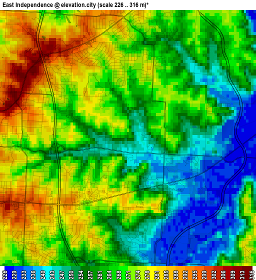
Below is the Elevation map of East Independence, which displays elevation range with different colors. Scale of the first map is from 226 to 316 m (741 to 1037 ft) with average elevation of 264.9 meters (=869 ft) [note 1]
These maps also provides idea of topography and contour of this city, they are displayed at different zoom levels. More info about maps, scale and edge coordinates you can find below images.
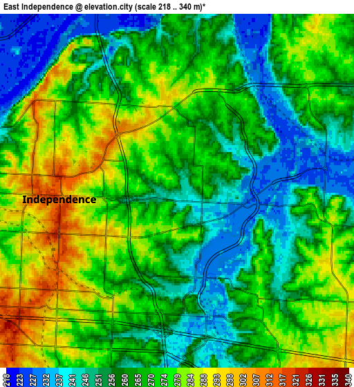
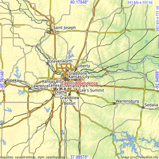
| \ | Map #1 | Map #2 | Topo.Map |
| Scale [m] | 226..316 m | 218..340 m | × |
| Scale [ft] | 741..1037 ft | 715..1115 ft | × |
| Average | 264.9 m = 869 ft | 266.2 m = 873 ft | × |
| Width | 7.58 km = 4.7 mi | 15.17 km = 9.4 mi | 242.7 km = 150.8 mi |
| Height | 7.58 km = 4.7 mi | 15.17 km = 9.4 mi | 242.7 km = 150.8 mi |
| ↑Max Latitude | 39.129658° | 39.163739° | 40.17848° |
| Latitude at center | 39.09556° | 39.09556° | 39.09556° |
| ↓Min Latitude | 39.061446° | 39.027316° | 37.99575° |
| ← Min Longitude | -94.399175° | -94.443121° | -95.76148° |
| Longitude center | -94.35523° | -94.35523° | -94.35523° |
| →Max Longitude | -94.311285° | -94.267339° | -92.94898° |
Nearby cities:
Cities around East Independence sort by population:
• Kansas City elevation 290 m
19.3 km,  271°
271°
• Independence 319 m
5.2 km,  264°
264°
• Lee's Summit 323 m
20.7 km,  186°
186°
• Blue Springs 300 m
10.8 km,  143°
143°
• Liberty 274 m
17.6 km,  341°
341°
• Raytown 310 m
13.5 km,  224°
224°
• Grain Valley 242 m
16.2 km,  123°
123°
• North Kansas City 227 m
18.3 km,  282°
282°
• Sugar Creek 250 m
7.9 km, 281°
• Buckner 231 m
14.1 km,  73°
73°
• Pleasant Valley 244 m
17.4 km,  320°
320°
• Claycomo 246 m
16.8 km, 315°
Multilingual:
 En español:
East Independence elevación 262 m.
 En France:
East Independence élévation 262 m.
 Auf Deutsch:
East Independence höhe über dem Meeresspiegel ist 262 m.

Sources and notes:
- [note 1] Map square and city borders are not equal. Map elevation data is calculated only from area inside that square.
- [src 1] Elevation data from geonames database provided with same terms of usage.
- [src 2] The elevation map of East Independence is generated using elevation data from NASA's 3 arcsec (90m) resolution SRTM data.
- [src 3] Base (background) map © OpenStreetMap contributors tiles are generated by Geofabrik and OpenTopoMap.
Copyright & License:
This East Independence Elevation Map is licensed under CC BY-SA. You may reuse any part from this page, if you give a proper credit by linking to this URL:
 More info on terms of use page.