Raytown elevation
Raytown (Missouri, Jackson County), United States elevation is 310 meters and Raytown elevation in feet is 1017 ft above sea level [src 1]. Raytown is a populated place (feature code) with elevation that is 31 meters (102 ft) bigger than average city elevation in United States.
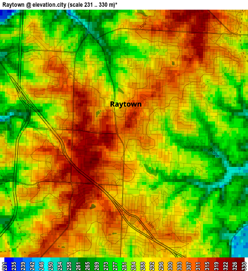
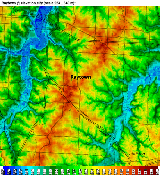
Below is the Elevation map of Raytown, which displays elevation range with different colors. Scale of the first map is from 231 to 330 m (758 to 1083 ft) with average elevation of 291.1 meters (=955 ft) [note 1]
These maps also provides idea of topography and contour of this city, they are displayed at different zoom levels. More info about maps, scale and edge coordinates you can find below images.
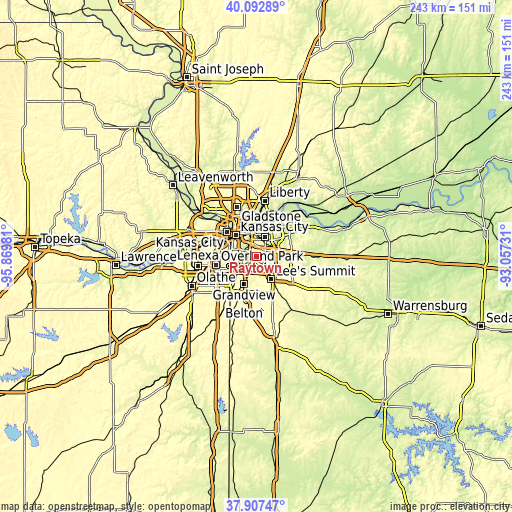
| \ | Map #1 | Map #2 | Topo.Map |
| Scale [m] | 231..330 m | 223..340 m | × |
| Scale [ft] | 758..1083 ft | 732..1115 ft | × |
| Average | 291.1 m = 955 ft | 279.9 m = 918 ft | × |
| Width | 7.59 km = 4.7 mi | 15.19 km = 9.4 mi | 243 km = 151 mi |
| Height | 7.59 km = 4.7 mi | 15.19 km = 9.4 mi | 243 km = 151 mi |
| ↑Max Latitude | 39.04276° | 39.076883° | 40.09289° |
| Latitude at center | 39.00862° | 39.00862° | 39.00862° |
| ↓Min Latitude | 38.974464° | 38.940292° | 37.90747° |
| ← Min Longitude | -94.507505° | -94.551451° | -95.86981° |
| Longitude center | -94.46356° | -94.46356° | -94.46356° |
| →Max Longitude | -94.419615° | -94.375669° | -93.05731° |
Nearby cities:
Cities around Raytown sort by population:
• Kansas City elevation 290 m
14.2 km,  315°
315°
• Independence 319 m
10.1 km,  24°
24°
• East Independence 262 m
13.5 km,  44°
44°
• Lee's Summit 323 m
13 km,  147°
147°
• Leawood 293 m
14 km,  250°
250°
• Grandview 324 m
14.9 km,  203°
203°
• Prairie Village 304 m
14.8 km,  262°
262°
• Roeland Park 308 m
14.9 km,  282°
282°
• Fairway 297 m
14.6 km, 275°
• Mission Hills 293 m
13.3 km,  274°
274°
• Sugar Creek 250 m
11.4 km,  8°
8°
• Westwood 294 m
13.7 km,  285°
285°
Multilingual:
 En español:
Raytown elevación 310 m.
 En France:
Raytown élévation 310 m.


Sources and notes:
- [note 1] Map square and city borders are not equal. Map elevation data is calculated only from area inside that square.
- [src 1] Elevation data from geonames database provided with same terms of usage.
- [src 2] The elevation map of Raytown is generated using elevation data from NASA's 3 arcsec (90m) resolution SRTM data.
- [src 3] Base (background) map © OpenStreetMap contributors tiles are generated by Geofabrik and OpenTopoMap.
Copyright & License:
This Raytown Elevation Map is licensed under CC BY-SA. You may reuse any part from this page, if you give a proper credit by linking to this URL:
 More info on terms of use page.