Lee's Summit elevation
Lee's Summit (Missouri, Jackson County), United States elevation is 323 meters and Lee's Summit elevation in feet is 1060 ft above sea level [src 1]. Lee's Summit is a populated place (feature code) with elevation that is 44 meters (144 ft) bigger than average city elevation in United States.
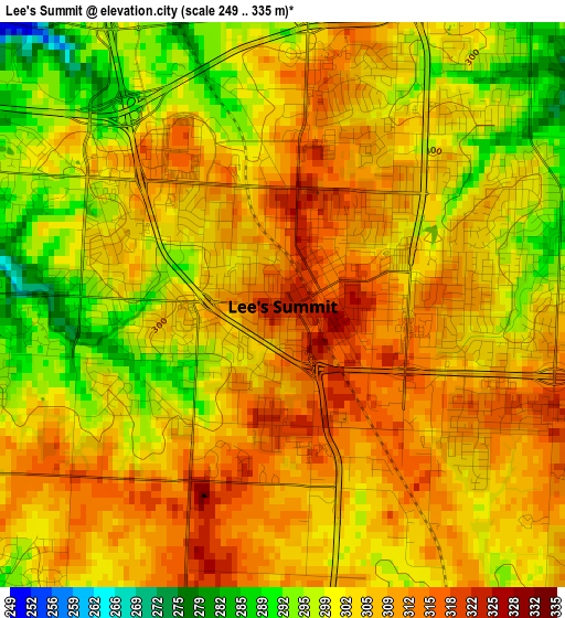
Below is the Elevation map of Lee's Summit, which displays elevation range with different colors. Scale of the first map is from 249 to 335 m (817 to 1099 ft) with average elevation of 304.2 meters (=998 ft) [note 1]
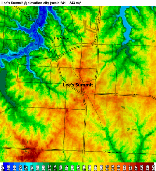
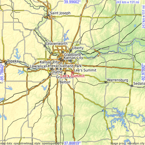
These maps also provides idea of topography and contour of this city, they are displayed at different zoom levels. More info about maps, scale and edge coordinates you can find below images.
| \ | Map #1 | Map #2 | Topo.Map |
| Scale [m] | 249..335 m | 241..343 m | × |
| Scale [ft] | 817..1099 ft | 791..1125 ft | × |
| Average | 304.2 m = 998 ft | 295.8 m = 970 ft | × |
| Width | 7.6 km = 4.7 mi | 15.21 km = 9.5 mi | 243.3 km = 151.2 mi |
| Height | 7.6 km = 4.7 mi | 15.21 km = 9.5 mi | 243.3 km = 151.2 mi |
| ↑Max Latitude | 38.945027° | 38.979197° | 39.99662° |
| Latitude at center | 38.91084° | 38.91084° | 38.91084° |
| ↓Min Latitude | 38.876637° | 38.842417° | 37.80819° |
| ← Min Longitude | -94.426115° | -94.470061° | -95.78842° |
| Longitude center | -94.38217° | -94.38217° | -94.38217° |
| →Max Longitude | -94.338225° | -94.294279° | -92.97592° |
Nearby cities:
Cities around Lee's Summit sort by population:
• Independence elevation 319 m
20.3 km,  351°
351°
• Blue Springs 300 m
14.7 km,  36°
36°
• Raytown 310 m
13 km,  327°
327°
• Grandview 324 m
13.3 km,  257°
257°
• Belton 340 m
17 km,  229°
229°
• Raymore 338 m
13.6 km,  206°
206°
• Grain Valley 242 m
19.7 km,  53°
53°
• Pleasant Hill 282 m
16.8 km,  144°
144°
• Greenwood 295 m
7.4 km,  153°
153°
• Lake Lotawana 281 m
12 km,  83°
83°
• Lake Winnebago 298 m
9.1 km,  166°
166°
• Lone Jack 316 m
18.6 km,  103°
103°
Multilingual:
 En español:
Lee's Summit elevación 323 m.
 En France:
Lee's Summit élévation 323 m.
 Auf Deutsch:
Lee’s Summit höhe über dem Meeresspiegel ist 323 m.

Sources and notes:
- [note 1] Map square and city borders are not equal. Map elevation data is calculated only from area inside that square.
- [src 1] Elevation data from geonames database provided with same terms of usage.
- [src 2] The elevation map of Lee's Summit is generated using elevation data from NASA's 3 arcsec (90m) resolution SRTM data.
- [src 3] Base (background) map © OpenStreetMap contributors tiles are generated by Geofabrik and OpenTopoMap.
Copyright & License:
This Lee's Summit Elevation Map is licensed under CC BY-SA. You may reuse any part from this page, if you give a proper credit by linking to this URL:
 More info on terms of use page.