Liberty elevation
Liberty (Missouri, Clay County), United States elevation is 274 meters and Liberty elevation in feet is 899 ft above sea level [src 1]. Liberty is a seat of a second-order administrative division (feature code) with elevation that is 5 meters (16 ft) smaller than average city elevation in United States.
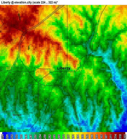
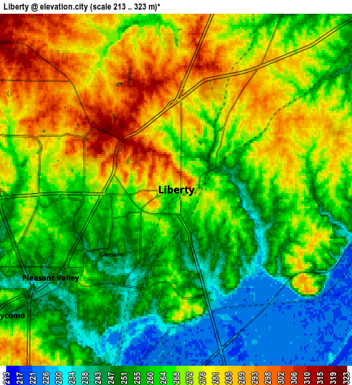
Below is the Elevation map of Liberty, which displays elevation range with different colors. Scale of the first map is from 224 to 322 m (735 to 1056 ft) with average elevation of 268.8 meters (=882 ft) [note 1]
These maps also provides idea of topography and contour of this city, they are displayed at different zoom levels. More info about maps, scale and edge coordinates you can find below images.
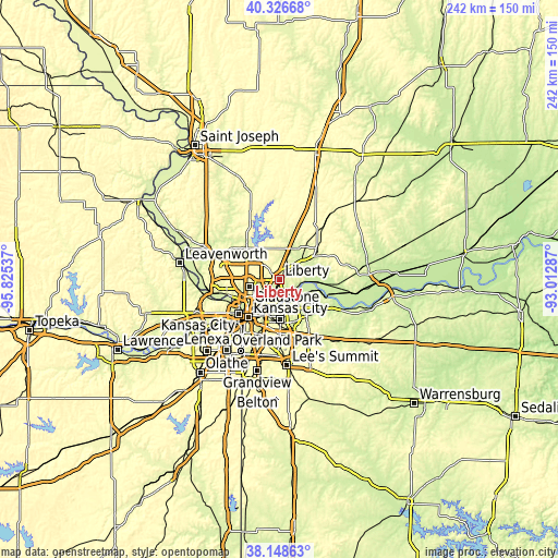
| \ | Map #1 | Map #2 | Topo.Map |
| Scale [m] | 224..322 m | 213..323 m | × |
| Scale [ft] | 735..1056 ft | 699..1060 ft | × |
| Average | 268.8 m = 882 ft | 265.6 m = 871 ft | × |
| Width | 7.57 km = 4.7 mi | 15.14 km = 9.4 mi | 242.2 km = 150.5 mi |
| Height | 7.57 km = 4.7 mi | 15.14 km = 9.4 mi | 242.2 km = 150.5 mi |
| ↑Max Latitude | 39.280135° | 39.314143° | 40.32668° |
| Latitude at center | 39.24611° | 39.24611° | 39.24611° |
| ↓Min Latitude | 39.212069° | 39.178011° | 38.14863° |
| ← Min Longitude | -94.463065° | -94.507011° | -95.82537° |
| Longitude center | -94.41912° | -94.41912° | -94.41912° |
| →Max Longitude | -94.375175° | -94.331229° | -93.01287° |
Nearby cities:
Cities around Liberty sort by population:
• Kansas City elevation 290 m
21.3 km,  220°
220°
• Independence 319 m
17.2 km,  178°
178°
• East Independence 262 m
17.6 km,  161°
161°
• Gladstone 292 m
12.6 km,  248°
248°
• Excelsior Springs 242 m
19.6 km,  58°
58°
• Kearney 264 m
14.4 km,  19°
19°
• Smithville 251 m
21 km,  318°
318°
• North Kansas City 227 m
17.9 km, 223°
• Sugar Creek 250 m
15.3 km,  188°
188°
• Riverside 236 m
18.4 km, 245°
• Pleasant Valley 244 m
6.5 km,  239°
239°
• Claycomo 246 m
8 km,  232°
232°
Multilingual:
 En español:
Liberty elevación 274 m.
 En France:
Liberty élévation 274 m.


Sources and notes:
- [note 1] Map square and city borders are not equal. Map elevation data is calculated only from area inside that square.
- [src 1] Elevation data from geonames database provided with same terms of usage.
- [src 2] The elevation map of Liberty is generated using elevation data from NASA's 3 arcsec (90m) resolution SRTM data.
- [src 3] Base (background) map © OpenStreetMap contributors tiles are generated by Geofabrik and OpenTopoMap.
Copyright & License:
This Liberty Elevation Map is licensed under CC BY-SA. You may reuse any part from this page, if you give a proper credit by linking to this URL:
 More info on terms of use page.