Cadiz elevation
Cadiz (Kentucky, Trigg County), United States elevation is 137 meters and Cadiz elevation in feet is 449 ft above sea level [src 1]. Cadiz is a seat of a second-order administrative division (feature code) with elevation that is 142 meters (466 ft) smaller than average city elevation in United States.
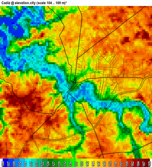
Below is the Elevation map of Cadiz, which displays elevation range with different colors. Scale of the first map is from 104 to 169 m (341 to 554 ft) with average elevation of 141.5 meters (=464 ft) [note 1]
These maps also provides idea of topography and contour of this city, they are displayed at different zoom levels. More info about maps, scale and edge coordinates you can find below images.
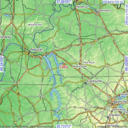
| \ | Map #1 | Topo.Map |
| Scale [m] | 104..169 m | × |
| Scale [ft] | 341..554 ft | × |
| Average | 141.5 m = 464 ft | × |
| Width | 7.82 km = 4.9 mi | 250.2 km = 155.5 mi |
| Height | 7.82 km = 4.9 mi | 250.2 km = 155.5 mi |
| ↑Max Latitude | 36.9002° | 37.98181° |
| Latitude at center | 36.86505° | 36.86505° |
| ↓Min Latitude | 36.829883° | 35.73173° |
| ← Min Longitude | -87.879245° | -89.24155° |
| Longitude center | -87.8353° | -87.8353° |
| →Max Longitude | -87.791355° | -86.42905° |
Nearby cities:
Cities around Cadiz sort by population:
• Hopkinsville elevation 159 m
30.6 km,  89°
89°
• Murray 164 m
51.3 km,  236°
236°
• Fort Campbell North 166 m
40.8 km,  125°
125°
• Oak Grove 166 m
41.4 km,  122°
122°
• Princeton 148 m
27.5 km,  351°
351°
• Benton 132 m
45.8 km,  268°
268°
• Dawson Springs 130 m
35.9 km,  20°
20°
• Eddyville 155 m
33.5 km,  319°
319°
• Calvert City 105 m
49.4 km,  292°
292°
• Dover 128 m
41.9 km,  180°
180°
• Earlington 132 m
53.8 km,  32°
32°
• Nortonville 124 m
49.7 km,  43°
43°
Multilingual:
 En español:
Cadiz elevación 137 m.
 En France:
Cadiz élévation 137 m.


Sources and notes:
- [note 1] Map square and city borders are not equal. Map elevation data is calculated only from area inside that square.
- [src 1] Elevation data from geonames database provided with same terms of usage.
- [src 2] The elevation map of Cadiz is generated using elevation data from NASA's 3 arcsec (90m) resolution SRTM data.
- [src 3] Base (background) map © OpenStreetMap contributors tiles are generated by Geofabrik and OpenTopoMap.
Copyright & License:
This Cadiz Elevation Map is licensed under CC BY-SA. You may reuse any part from this page, if you give a proper credit by linking to this URL:
 More info on terms of use page.