Princeton elevation
Princeton (Kentucky, Caldwell County), United States elevation is 148 meters and Princeton elevation in feet is 486 ft above sea level [src 1]. Princeton is a seat of a second-order administrative division (feature code) with elevation that is 131 meters (430 ft) smaller than average city elevation in United States.
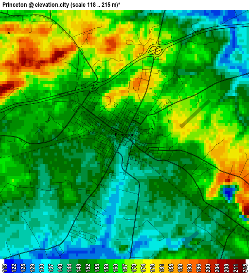
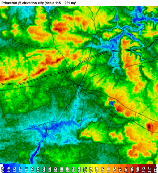
Below is the Elevation map of Princeton, which displays elevation range with different colors. Scale of the first map is from 118 to 215 m (387 to 705 ft) with average elevation of 155.7 meters (=511 ft) [note 1]
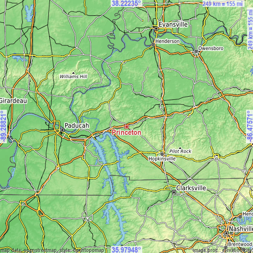
These maps also provides idea of topography and contour of this city, they are displayed at different zoom levels. More info about maps, scale and edge coordinates you can find below images.
| \ | Map #1 | Map #2 | Topo.Map |
| Scale [m] | 118..215 m | 115..221 m | × |
| Scale [ft] | 387..705 ft | 377..725 ft | × |
| Average | 155.7 m = 511 ft | 158.9 m = 521 ft | × |
| Width | 7.79 km = 4.8 mi | 15.59 km = 9.7 mi | 249.4 km = 155 mi |
| Height | 7.79 km = 4.8 mi | 15.59 km = 9.7 mi | 249.4 km = 155 mi |
| ↑Max Latitude | 37.144258° | 37.179279° | 38.22235° |
| Latitude at center | 37.10922° | 37.10922° | 37.10922° |
| ↓Min Latitude | 37.074166° | 37.039096° | 35.97948° |
| ← Min Longitude | -87.925905° | -87.969851° | -89.28821° |
| Longitude center | -87.88196° | -87.88196° | -87.88196° |
| →Max Longitude | -87.838015° | -87.794069° | -86.47571° |
Nearby cities:
Cities around Princeton sort by population:
• Hopkinsville elevation 159 m
44 km,  127°
127°
• Madisonville 144 m
41.7 km,  54°
54°
• Providence 135 m
33.7 km,  18°
18°
• Marion 181 m
30.5 km,  324°
324°
• Dawson Springs 130 m
18 km,  68°
68°
• Cadiz 137 m
27.5 km,  171°
171°
• Eddyville 155 m
17.7 km,  264°
264°
• Calvert City 105 m
42.4 km, 258°
• Earlington 132 m
37.6 km,  60°
60°
• Nortonville 124 m
39.1 km,  76°
76°
• Clay 115 m
41.2 km,  7°
7°
• Smithland 109 m
46.3 km,  274°
274°
Multilingual:
 En español:
Princeton elevación 148 m.
 En France:
Princeton élévation 148 m.
 Auf Deutsch:
Princeton höhe über dem Meeresspiegel ist 148 m.

Sources and notes:
- [note 1] Map square and city borders are not equal. Map elevation data is calculated only from area inside that square.
- [src 1] Elevation data from geonames database provided with same terms of usage.
- [src 2] The elevation map of Princeton is generated using elevation data from NASA's 3 arcsec (90m) resolution SRTM data.
- [src 3] Base (background) map © OpenStreetMap contributors tiles are generated by Geofabrik and OpenTopoMap.
Copyright & License:
This Princeton Elevation Map is licensed under CC BY-SA. You may reuse any part from this page, if you give a proper credit by linking to this URL:
 More info on terms of use page.