Murray elevation
Murray (Kentucky, Calloway County), United States elevation is 164 meters and Murray elevation in feet is 538 ft above sea level [src 1]. Murray is a seat of a second-order administrative division (feature code) with elevation that is 115 meters (377 ft) smaller than average city elevation in United States.
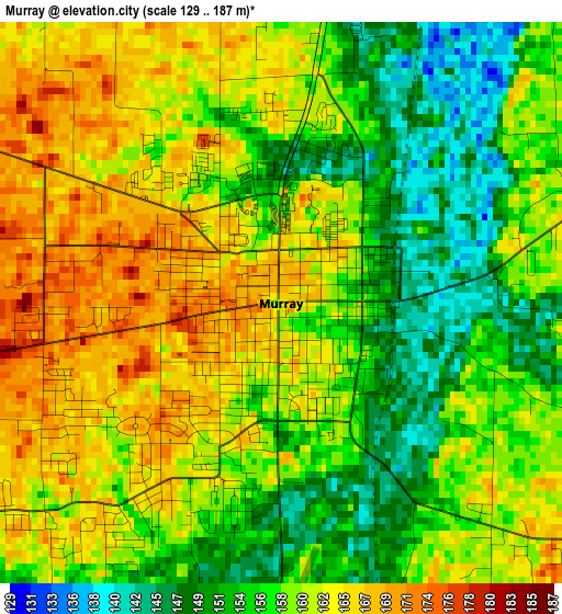
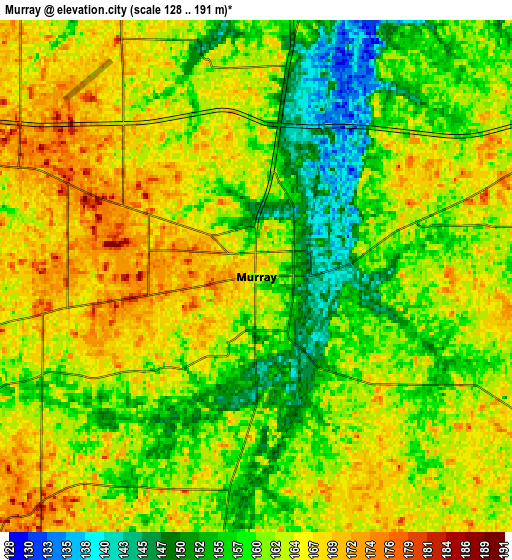
Below is the Elevation map of Murray, which displays elevation range with different colors. Scale of the first map is from 129 to 187 m (423 to 614 ft) with average elevation of 158.8 meters (=521 ft) [note 1]
These maps also provides idea of topography and contour of this city, they are displayed at different zoom levels. More info about maps, scale and edge coordinates you can find below images.
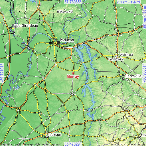
| \ | Map #1 | Map #2 | Topo.Map |
| Scale [m] | 129..187 m | 128..191 m | × |
| Scale [ft] | 423..614 ft | 420..627 ft | × |
| Average | 158.8 m = 521 ft | 161.7 m = 531 ft | × |
| Width | 7.84 km = 4.9 mi | 15.69 km = 9.7 mi | 251 km = 156 mi |
| Height | 7.84 km = 4.9 mi | 15.69 km = 9.7 mi | 251 km = 156 mi |
| ↑Max Latitude | 36.645597° | 36.680848° | 37.73085° |
| Latitude at center | 36.61033° | 36.61033° | 36.61033° |
| ↓Min Latitude | 36.575047° | 36.539747° | 35.47329° |
| ← Min Longitude | -88.358705° | -88.402651° | -89.72101° |
| Longitude center | -88.31476° | -88.31476° | -88.31476° |
| →Max Longitude | -88.270815° | -88.226869° | -86.90851° |
Nearby cities:
Cities around Murray sort by population:
• Paris elevation 158 m
34.3 km,  181°
181°
• Mayfield 146 m
32.2 km,  296°
296°
• Reidland 124 m
49.2 km,  336°
336°
• Benton 132 m
27.6 km,  353°
353°
• Dresden 132 m
49.9 km,  224°
224°
• Cadiz 137 m
51.3 km,  56°
56°
• Calvert City 105 m
47.1 km,  356°
356°
• South Fulton 111 m
51.5 km,  256°
256°
• Fulton 112 m
51.3 km, 256°
• Ledbetter 108 m
50.7 km, 343°
• Dover 128 m
44.7 km,  107°
107°
• Gleason 128 m
51.5 km,  211°
211°
Multilingual:
 En español:
Murray elevación 164 m.
 En France:
Murray élévation 164 m.


Sources and notes:
- [note 1] Map square and city borders are not equal. Map elevation data is calculated only from area inside that square.
- [src 1] Elevation data from geonames database provided with same terms of usage.
- [src 2] The elevation map of Murray is generated using elevation data from NASA's 3 arcsec (90m) resolution SRTM data.
- [src 3] Base (background) map © OpenStreetMap contributors tiles are generated by Geofabrik and OpenTopoMap.
Copyright & License:
This Murray Elevation Map is licensed under CC BY-SA. You may reuse any part from this page, if you give a proper credit by linking to this URL:
 More info on terms of use page.