Benton elevation
Benton (Kentucky, Marshall County), United States elevation is 132 meters and Benton elevation in feet is 433 ft above sea level [src 1]. Benton is a seat of a second-order administrative division (feature code) with elevation that is 147 meters (482 ft) smaller than average city elevation in United States.
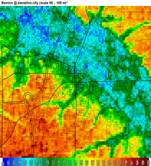
Below is the Elevation map of Benton, which displays elevation range with different colors. Scale of the first map is from 98 to 169 m (322 to 554 ft) with average elevation of 131.1 meters (=430 ft) [note 1]
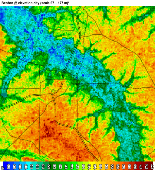
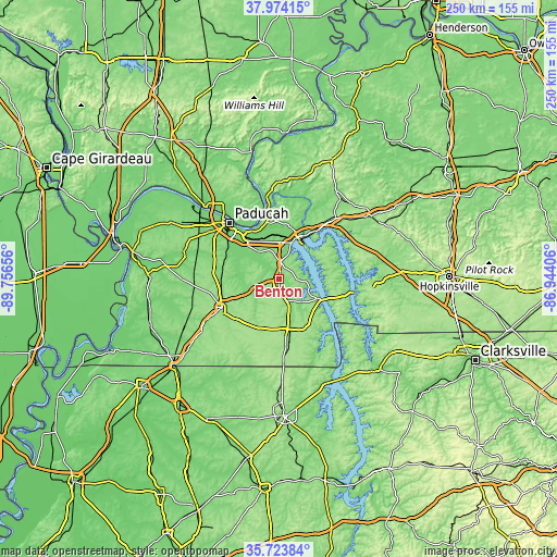
These maps also provides idea of topography and contour of this city, they are displayed at different zoom levels. More info about maps, scale and edge coordinates you can find below images.
| \ | Map #1 | Map #2 | Topo.Map |
| Scale [m] | 98..169 m | 97..177 m | × |
| Scale [ft] | 322..554 ft | 318..581 ft | × |
| Average | 131.1 m = 430 ft | 136.9 m = 449 ft | × |
| Width | 7.82 km = 4.9 mi | 15.64 km = 9.7 mi | 250.2 km = 155.5 mi |
| Height | 7.82 km = 4.9 mi | 15.64 km = 9.7 mi | 250.2 km = 155.5 mi |
| ↑Max Latitude | 36.892434° | 36.927572° | 37.97415° |
| Latitude at center | 36.85728° | 36.85728° | 36.85728° |
| ↓Min Latitude | 36.82211° | 36.786924° | 35.72384° |
| ← Min Longitude | -88.394255° | -88.438201° | -89.75656° |
| Longitude center | -88.35031° | -88.35031° | -88.35031° |
| →Max Longitude | -88.306365° | -88.262419° | -86.94406° |
Nearby cities:
Cities around Benton sort by population:
• Paducah elevation 104 m
33.5 km,  318°
318°
• Murray 164 m
27.6 km,  173°
173°
• Mayfield 146 m
28.6 km,  243°
243°
• Farley 105 m
28.6 km, 317°
• Hendron 114 m
32 km,  309°
309°
• Massac 145 m
38.2 km,  297°
297°
• Reidland 124 m
24 km, 317°
• Cadiz 137 m
45.8 km,  88°
88°
• Eddyville 155 m
35.7 km,  42°
42°
• Calvert City 105 m
19.6 km,  0°
0°
• Ledbetter 108 m
24 km,  331°
331°
• Smithland 109 m
31.7 km,  351°
351°
Multilingual:
 En español:
Benton elevación 132 m.
 En France:
Benton élévation 132 m.


Sources and notes:
- [note 1] Map square and city borders are not equal. Map elevation data is calculated only from area inside that square.
- [src 1] Elevation data from geonames database provided with same terms of usage.
- [src 2] The elevation map of Benton is generated using elevation data from NASA's 3 arcsec (90m) resolution SRTM data.
- [src 3] Base (background) map © OpenStreetMap contributors tiles are generated by Geofabrik and OpenTopoMap.
Copyright & License:
This Benton Elevation Map is licensed under CC BY-SA. You may reuse any part from this page, if you give a proper credit by linking to this URL:
 More info on terms of use page.