Pana elevation
Pana (Illinois, Christian County), United States elevation is 212 meters and Pana elevation in feet is 696 ft above sea level [src 1]. Pana is a populated place (feature code) with elevation that is 67 meters (220 ft) smaller than average city elevation in United States.
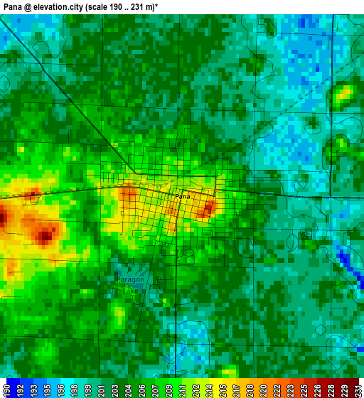
Below is the Elevation map of Pana, which displays elevation range with different colors. Scale of the first map is from 190 to 231 m (623 to 758 ft) with average elevation of 203.8 meters (=669 ft) [note 1]
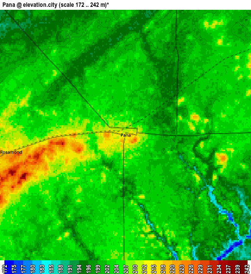
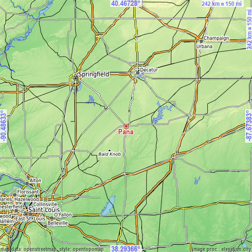
These maps also provides idea of topography and contour of this city, they are displayed at different zoom levels. More info about maps, scale and edge coordinates you can find below images.
| \ | Map #1 | Map #2 | Topo.Map |
| Scale [m] | 190..231 m | 172..242 m | × |
| Scale [ft] | 623..758 ft | 564..794 ft | × |
| Average | 203.8 m = 669 ft | 202.6 m = 665 ft | × |
| Width | 7.55 km = 4.7 mi | 15.11 km = 9.4 mi | 241.7 km = 150.2 mi |
| Height | 7.55 km = 4.7 mi | 15.11 km = 9.4 mi | 241.7 km = 150.2 mi |
| ↑Max Latitude | 39.422885° | 39.456824° | 40.46728° |
| Latitude at center | 39.38893° | 39.38893° | 39.38893° |
| ↓Min Latitude | 39.354958° | 39.32097° | 38.29366° |
| ← Min Longitude | -89.124025° | -89.167971° | -90.48633° |
| Longitude center | -89.08008° | -89.08008° | -89.08008° |
| →Max Longitude | -89.036135° | -88.992189° | -87.67383° |
Nearby cities:
Cities around Pana sort by population:
• Taylorville elevation 191 m
25.6 km,  314°
314°
• Shelbyville 200 m
25 km,  85°
85°
• Nokomis 206 m
20.1 km,  241°
241°
• Moweaqua 195 m
26.7 km,  11°
11°
• Kincaid 185 m
36.3 km, 307°
• Bethany 202 m
40.9 km,  45°
45°
• Macon 215 m
36.7 km, 11°
• Assumption 196 m
14.9 km, 10°
• Blue Mound 193 m
34.9 km,  353°
353°
• Edinburg 180 m
39.9 km,  318°
318°
• Morrisonville 193 m
32.5 km,  276°
276°
• Ramsey 188 m
27.3 km,  185°
185°
Multilingual:
 En español:
Pana elevación 212 m.
 En France:
Pana élévation 212 m.


Sources and notes:
- [note 1] Map square and city borders are not equal. Map elevation data is calculated only from area inside that square.
- [src 1] Elevation data from geonames database provided with same terms of usage.
- [src 2] The elevation map of Pana is generated using elevation data from NASA's 3 arcsec (90m) resolution SRTM data.
- [src 3] Base (background) map © OpenStreetMap contributors tiles are generated by Geofabrik and OpenTopoMap.
Copyright & License:
This Pana Elevation Map is licensed under CC BY-SA. You may reuse any part from this page, if you give a proper credit by linking to this URL:
 More info on terms of use page.