Edinburg elevation
Edinburg (Illinois, Christian County), United States elevation is 180 meters and Edinburg elevation in feet is 591 ft above sea level [src 1]. Edinburg is a populated place (feature code) with elevation that is 99 meters (325 ft) smaller than average city elevation in United States.
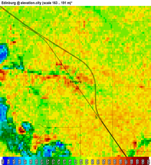
Below is the Elevation map of Edinburg, which displays elevation range with different colors. Scale of the first map is from 163 to 191 m (535 to 627 ft) with average elevation of 179 meters (=587 ft) [note 1]
These maps also provides idea of topography and contour of this city, they are displayed at different zoom levels. More info about maps, scale and edge coordinates you can find below images.
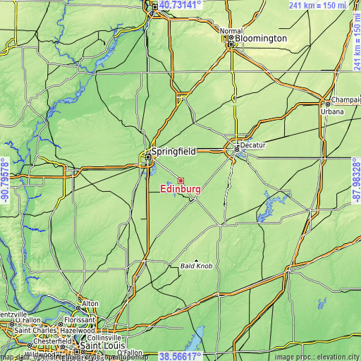
| \ | Map #1 | Topo.Map |
| Scale [m] | 163..191 m | × |
| Scale [ft] | 535..627 ft | × |
| Average | 179 m = 587 ft | × |
| Width | 7.52 km = 4.7 mi | 240.8 km = 149.6 mi |
| Height | 7.52 km = 4.7 mi | 240.7 km = 149.6 mi |
| ↑Max Latitude | 39.691094° | 40.73141° |
| Latitude at center | 39.65727° | 39.65727° |
| ↓Min Latitude | 39.623429° | 38.56617° |
| ← Min Longitude | -89.433475° | -90.79578° |
| Longitude center | -89.38953° | -89.38953° |
| →Max Longitude | -89.345585° | -87.98328° |
Nearby cities:
Cities around Edinburg sort by population:
• Springfield elevation 184 m
27 km,  306°
306°
• Chatham 185 m
27 km,  274°
274°
• Taylorville 191 m
14.5 km,  145°
145°
• Rochester 172 m
15.9 km, 310°
• Riverton 177 m
24.4 km,  328°
328°
• Pawnee 186 m
17.9 km,  245°
245°
• Southern View 189 m
25.2 km,  296°
296°
• Kincaid 185 m
7.9 km,  195°
195°
• Grandview 181 m
26.4 km, 312°
• Divernon 187 m
25.1 km, 246°
• Blue Mound 193 m
23.3 km,  77°
77°
• Morrisonville 193 m
27 km,  192°
192°
Multilingual:
 En español:
Edinburg elevación 180 m.
 En France:
Edinburg élévation 180 m.
 Auf Deutsch:
Edinburg höhe über dem Meeresspiegel ist 180 m.

Sources and notes:
- [note 1] Map square and city borders are not equal. Map elevation data is calculated only from area inside that square.
- [src 1] Elevation data from geonames database provided with same terms of usage.
- [src 2] The elevation map of Edinburg is generated using elevation data from NASA's 3 arcsec (90m) resolution SRTM data.
- [src 3] Base (background) map © OpenStreetMap contributors tiles are generated by Geofabrik and OpenTopoMap.
Copyright & License:
This Edinburg Elevation Map is licensed under CC BY-SA. You may reuse any part from this page, if you give a proper credit by linking to this URL:
 More info on terms of use page.