Ramsey elevation
Ramsey (Illinois, Fayette County), United States elevation is 188 meters and Ramsey elevation in feet is 617 ft above sea level [src 1]. Ramsey is a populated place (feature code) with elevation that is 91 meters (299 ft) smaller than average city elevation in United States.
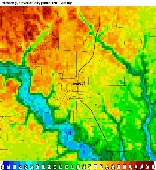
Below is the Elevation map of Ramsey, which displays elevation range with different colors. Scale of the first map is from 150 to 209 m (492 to 686 ft) with average elevation of 182.8 meters (=600 ft) [note 1]
These maps also provides idea of topography and contour of this city, they are displayed at different zoom levels. More info about maps, scale and edge coordinates you can find below images.
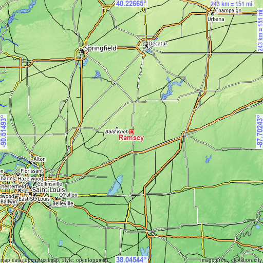
| \ | Map #1 | Topo.Map |
| Scale [m] | 150..209 m | × |
| Scale [ft] | 492..686 ft | × |
| Average | 182.8 m = 600 ft | × |
| Width | 7.58 km = 4.7 mi | 242.5 km = 150.7 mi |
| Height | 7.58 km = 4.7 mi | 242.5 km = 150.7 mi |
| ↑Max Latitude | 39.178564° | 40.22665° |
| Latitude at center | 39.14449° | 39.14449° |
| ↓Min Latitude | 39.1104° | 38.04544° |
| ← Min Longitude | -89.152625° | -90.51493° |
| Longitude center | -89.10868° | -89.10868° |
| →Max Longitude | -89.064735° | -87.70243° |
Nearby cities:
Cities around Ramsey sort by population:
• Taylorville elevation 191 m
47.7 km,  340°
340°
• Vandalia 161 m
20.5 km,  176°
176°
• Litchfield 209 m
47.2 km,  274°
274°
• Greenville 190 m
38.4 km,  223°
223°
• Hillsboro 190 m
33.4 km, 273°
• Pana 212 m
27.3 km,  5°
5°
• Shelbyville 200 m
40 km,  43°
43°
• Altamont 190 m
32.4 km,  106°
106°
• Nokomis 206 m
23.1 km,  318°
318°
• Saint Elmo 187 m
26 km,  120°
120°
• Assumption 196 m
42.1 km, 7°
• Morrisonville 193 m
42.8 km, 315°
Multilingual:
 En español:
Ramsey elevación 188 m.
 En France:
Ramsey élévation 188 m.


Sources and notes:
- [note 1] Map square and city borders are not equal. Map elevation data is calculated only from area inside that square.
- [src 1] Elevation data from geonames database provided with same terms of usage.
- [src 2] The elevation map of Ramsey is generated using elevation data from NASA's 3 arcsec (90m) resolution SRTM data.
- [src 3] Base (background) map © OpenStreetMap contributors tiles are generated by Geofabrik and OpenTopoMap.
Copyright & License:
This Ramsey Elevation Map is licensed under CC BY-SA. You may reuse any part from this page, if you give a proper credit by linking to this URL:
 More info on terms of use page.