Martinsville elevation
Martinsville (Illinois, Clark County), United States elevation is 188 meters and Martinsville elevation in feet is 617 ft above sea level [src 1]. Martinsville is a populated place (feature code) with elevation that is 91 meters (299 ft) smaller than average city elevation in United States.
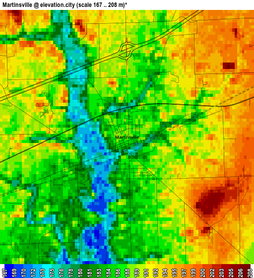
Below is the Elevation map of Martinsville, which displays elevation range with different colors. Scale of the first map is from 167 to 208 m (548 to 682 ft) with average elevation of 188.3 meters (=618 ft) [note 1]
These maps also provides idea of topography and contour of this city, they are displayed at different zoom levels. More info about maps, scale and edge coordinates you can find below images.
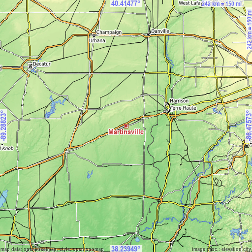
| \ | Map #1 | Topo.Map |
| Scale [m] | 167..208 m | × |
| Scale [ft] | 548..682 ft | × |
| Average | 188.3 m = 618 ft | × |
| Width | 7.56 km = 4.7 mi | 241.9 km = 150.3 mi |
| Height | 7.56 km = 4.7 mi | 241.9 km = 150.3 mi |
| ↑Max Latitude | 39.369571° | 40.41477° |
| Latitude at center | 39.33559° | 39.33559° |
| ↓Min Latitude | 39.301592° | 38.23949° |
| ← Min Longitude | -87.925925° | -89.28823° |
| Longitude center | -87.88198° | -87.88198° |
| →Max Longitude | -87.838035° | -86.47573° |
Nearby cities:
Cities around Martinsville sort by population:
• Terre Haute elevation 152 m
42.8 km,  70°
70°
• Charleston 208 m
30.9 km,  305°
305°
• Paris 223 m
34.5 km,  27°
27°
• Robinson 163 m
38.7 km,  161°
161°
• Marshall 193 m
17.3 km, 69°
• Casey 199 m
10.3 km,  246°
246°
• West Terre Haute 143 m
39.8 km, 68°
• Greenup 182 m
26.1 km, 248°
• Oblong 156 m
37.2 km,  183°
183°
• Palestine 141 m
43.6 km,  147°
147°
• Toledo 183 m
31.9 km,  257°
257°
• Farmersburg 171 m
44.1 km,  102°
102°
Multilingual:
 En español:
Martinsville elevación 188 m.
 En France:
Martinsville élévation 188 m.
 Auf Deutsch:
Martinsville höhe über dem Meeresspiegel ist 188 m.

Sources and notes:
- [note 1] Map square and city borders are not equal. Map elevation data is calculated only from area inside that square.
- [src 1] Elevation data from geonames database provided with same terms of usage.
- [src 2] The elevation map of Martinsville is generated using elevation data from NASA's 3 arcsec (90m) resolution SRTM data.
- [src 3] Base (background) map © OpenStreetMap contributors tiles are generated by Geofabrik and OpenTopoMap.
Copyright & License:
This Martinsville Elevation Map is licensed under CC BY-SA. You may reuse any part from this page, if you give a proper credit by linking to this URL:
 More info on terms of use page.