Toledo elevation
Toledo (Illinois, Cumberland County), United States elevation is 183 meters and Toledo elevation in feet is 600 ft above sea level [src 1]. Toledo is a seat of a second-order administrative division (feature code) with elevation that is 96 meters (315 ft) smaller than average city elevation in United States.
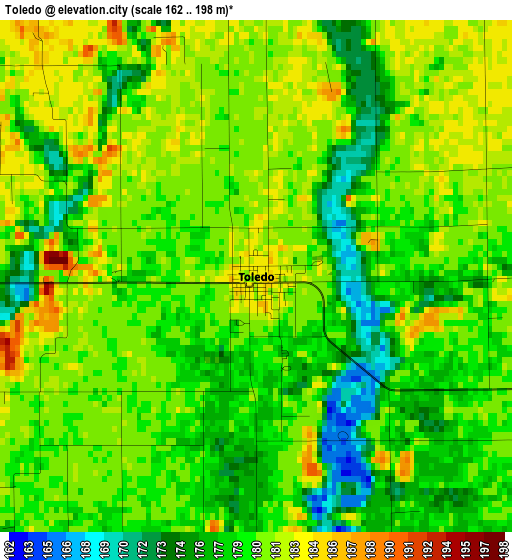
Below is the Elevation map of Toledo, which displays elevation range with different colors. Scale of the first map is from 162 to 198 m (531 to 650 ft) with average elevation of 179.4 meters (=589 ft) [note 1]
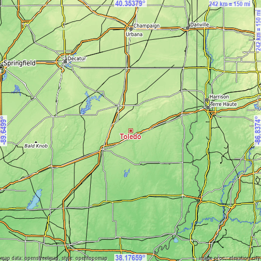
These maps also provides idea of topography and contour of this city, they are displayed at different zoom levels. More info about maps, scale and edge coordinates you can find below images.
| \ | Map #1 | Topo.Map |
| Scale [m] | 162..198 m | × |
| Scale [ft] | 531..650 ft | × |
| Average | 179.4 m = 589 ft | × |
| Width | 7.57 km = 4.7 mi | 242.1 km = 150.4 mi |
| Height | 7.57 km = 4.7 mi | 242.1 km = 150.4 mi |
| ↑Max Latitude | 39.307661° | 40.35379° |
| Latitude at center | 39.27365° | 39.27365° |
| ↓Min Latitude | 39.239622° | 38.17659° |
| ← Min Longitude | -88.287595° | -89.6499° |
| Longitude center | -88.24365° | -88.24365° |
| →Max Longitude | -88.199705° | -86.8374° |
Nearby cities:
Cities around Toledo sort by population:
• Charleston elevation 208 m
25.4 km,  13°
13°
• Mattoon 227 m
25.8 km,  334°
334°
• Effingham 181 m
31 km,  236°
236°
• Arcola 207 m
46 km,  353°
353°
• Newton 165 m
32.2 km,  167°
167°
• Casey 199 m
21.8 km,  82°
82°
• Neoga 203 m
18.7 km,  285°
285°
• Teutopolis 185 m
25.1 km,  231°
231°
• Greenup 182 m
7.5 km,  112°
112°
• Oblong 156 m
41.8 km,  136°
136°
• Windsor 216 m
35.5 km,  301°
301°
• Martinsville 188 m
31.9 km, 77°
Multilingual:
 En español:
Toledo elevación 183 m.
 En France:
Toledo élévation 183 m.


Sources and notes:
- [note 1] Map square and city borders are not equal. Map elevation data is calculated only from area inside that square.
- [src 1] Elevation data from geonames database provided with same terms of usage.
- [src 2] The elevation map of Toledo is generated using elevation data from NASA's 3 arcsec (90m) resolution SRTM data.
- [src 3] Base (background) map © OpenStreetMap contributors tiles are generated by Geofabrik and OpenTopoMap.
Copyright & License:
This Toledo Elevation Map is licensed under CC BY-SA. You may reuse any part from this page, if you give a proper credit by linking to this URL:
 More info on terms of use page.