Windsor elevation
Windsor (Illinois, Shelby County), United States elevation is 216 meters and Windsor elevation in feet is 709 ft above sea level [src 1]. Windsor is a populated place (feature code) with elevation that is 63 meters (207 ft) smaller than average city elevation in United States.
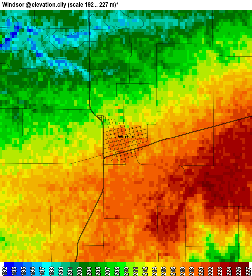
Below is the Elevation map of Windsor, which displays elevation range with different colors. Scale of the first map is from 192 to 227 m (630 to 745 ft) with average elevation of 212.3 meters (=697 ft) [note 1]
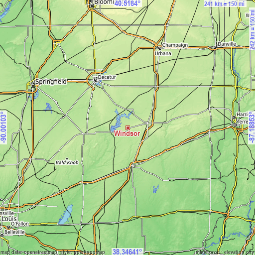
These maps also provides idea of topography and contour of this city, they are displayed at different zoom levels. More info about maps, scale and edge coordinates you can find below images.
| \ | Map #1 | Topo.Map |
| Scale [m] | 192..227 m | × |
| Scale [ft] | 630..745 ft | × |
| Average | 212.3 m = 697 ft | × |
| Width | 7.55 km = 4.7 mi | 241.5 km = 150.1 mi |
| Height | 7.55 km = 4.7 mi | 241.5 km = 150.1 mi |
| ↑Max Latitude | 39.4748° | 40.5184° |
| Latitude at center | 39.44087° | 39.44087° |
| ↓Min Latitude | 39.406924° | 38.34641° |
| ← Min Longitude | -88.638725° | -90.00103° |
| Longitude center | -88.59478° | -88.59478° |
| →Max Longitude | -88.550835° | -87.18853° |
Nearby cities:
Cities around Windsor sort by population:
• Charleston elevation 208 m
36.5 km,  80°
80°
• Mattoon 227 m
19.6 km, 76°
• Effingham 181 m
35.9 km,  172°
172°
• Shelbyville 200 m
17.2 km,  257°
257°
• Sullivan 207 m
17.7 km,  356°
356°
• Arcola 207 m
36.7 km,  42°
42°
• Arthur 202 m
32.2 km,  19°
19°
• Neoga 203 m
18.2 km,  137°
137°
• Teutopolis 185 m
35.8 km,  162°
162°
• Bethany 202 m
25.9 km,  331°
331°
• Toledo 183 m
35.5 km,  121°
121°
• Lovington 207 m
30.7 km,  353°
353°
Multilingual:
 En español:
Windsor elevación 216 m.
 En France:
Windsor élévation 216 m.


Sources and notes:
- [note 1] Map square and city borders are not equal. Map elevation data is calculated only from area inside that square.
- [src 1] Elevation data from geonames database provided with same terms of usage.
- [src 2] The elevation map of Windsor is generated using elevation data from NASA's 3 arcsec (90m) resolution SRTM data.
- [src 3] Base (background) map © OpenStreetMap contributors tiles are generated by Geofabrik and OpenTopoMap.
Copyright & License:
This Windsor Elevation Map is licensed under CC BY-SA. You may reuse any part from this page, if you give a proper credit by linking to this URL:
 More info on terms of use page.