Palestine elevation
Palestine (Illinois, Crawford County), United States elevation is 141 meters and Palestine elevation in feet is 463 ft above sea level [src 1]. Palestine is a populated place (feature code) with elevation that is 138 meters (453 ft) smaller than average city elevation in United States.
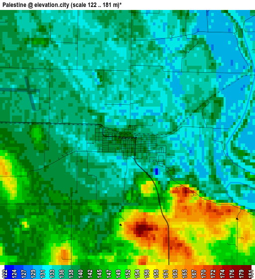
Below is the Elevation map of Palestine, which displays elevation range with different colors. Scale of the first map is from 122 to 181 m (400 to 594 ft) with average elevation of 140.3 meters (=460 ft) [note 1]
These maps also provides idea of topography and contour of this city, they are displayed at different zoom levels. More info about maps, scale and edge coordinates you can find below images.
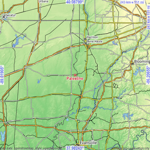
| \ | Map #1 | Topo.Map |
| Scale [m] | 122..181 m | × |
| Scale [ft] | 400..594 ft | × |
| Average | 140.3 m = 460 ft | × |
| Width | 7.59 km = 4.7 mi | 243 km = 151 mi |
| Height | 7.59 km = 4.7 mi | 243 km = 151 mi |
| ↑Max Latitude | 39.037792° | 40.08799° |
| Latitude at center | 39.00365° | 39.00365° |
| ↓Min Latitude | 38.969492° | 37.90243° |
| ← Min Longitude | -87.656745° | -89.01905° |
| Longitude center | -87.6128° | -87.6128° |
| →Max Longitude | -87.568855° | -86.20655° |
Nearby cities:
Cities around Palestine sort by population:
• Vincennes elevation 131 m
37 km,  168°
168°
• Robinson 163 m
10.9 km,  270°
270°
• Linton 165 m
38.8 km,  84°
84°
• Lawrenceville 143 m
31.1 km,  191°
191°
• Sullivan 163 m
20.6 km,  60°
60°
• Sumner 140 m
38.5 km,  214°
214°
• Bicknell 156 m
36.7 km,  134°
134°
• Jasonville 192 m
39.9 km, 63°
• Bridgeport 135 m
35.5 km,  201°
201°
• Oblong 156 m
25.6 km, 269°
• Shelburn 164 m
27.1 km,  44°
44°
• Farmersburg 171 m
33.7 km, 36°
Multilingual:
 En español:
Palestine elevación 141 m.
 En France:
Palestine élévation 141 m.
 Auf Deutsch:
Palestine höhe über dem Meeresspiegel ist 141 m.

Sources and notes:
- [note 1] Map square and city borders are not equal. Map elevation data is calculated only from area inside that square.
- [src 1] Elevation data from geonames database provided with same terms of usage.
- [src 2] The elevation map of Palestine is generated using elevation data from NASA's 3 arcsec (90m) resolution SRTM data.
- [src 3] Base (background) map © OpenStreetMap contributors tiles are generated by Geofabrik and OpenTopoMap.
Copyright & License:
This Palestine Elevation Map is licensed under CC BY-SA. You may reuse any part from this page, if you give a proper credit by linking to this URL:
 More info on terms of use page.