Lawrenceville elevation
Lawrenceville (Illinois, Lawrence County), United States elevation is 143 meters and Lawrenceville elevation in feet is 469 ft above sea level [src 1]. Lawrenceville is a seat of a second-order administrative division (feature code) with elevation that is 136 meters (446 ft) smaller than average city elevation in United States.
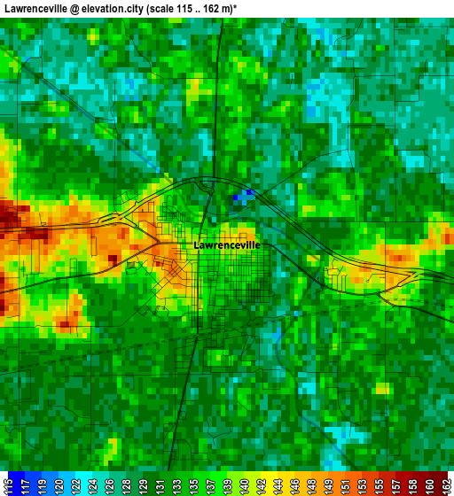
Below is the Elevation map of Lawrenceville, which displays elevation range with different colors. Scale of the first map is from 115 to 162 m (377 to 531 ft) with average elevation of 132.5 meters (=435 ft) [note 1]
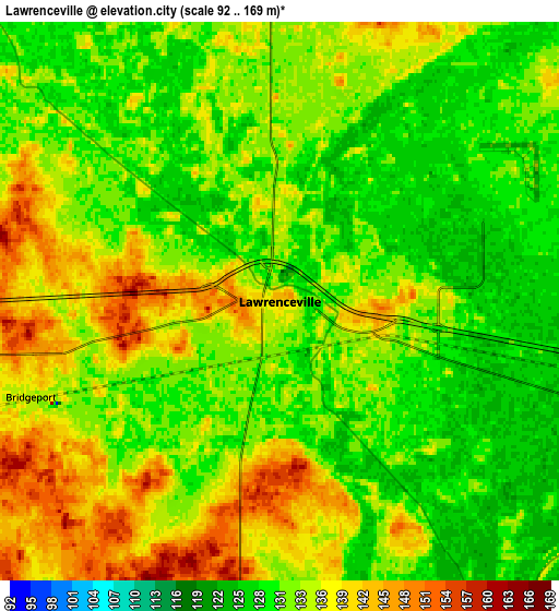
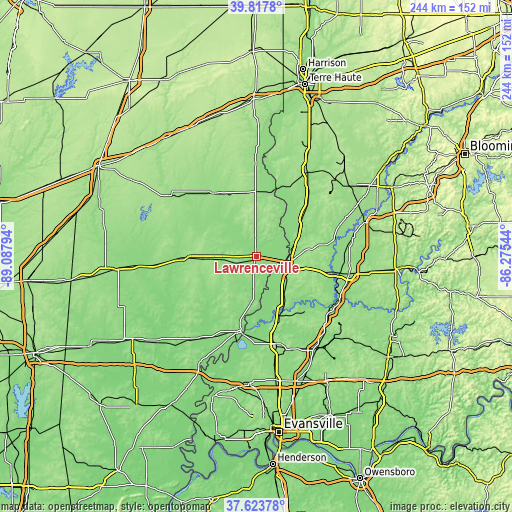
These maps also provides idea of topography and contour of this city, they are displayed at different zoom levels. More info about maps, scale and edge coordinates you can find below images.
| \ | Map #1 | Map #2 | Topo.Map |
| Scale [m] | 115..162 m | 92..169 m | × |
| Scale [ft] | 377..531 ft | 302..554 ft | × |
| Average | 132.5 m = 435 ft | 133.9 m = 439 ft | × |
| Width | 7.62 km = 4.7 mi | 15.25 km = 9.5 mi | 244 km = 151.6 mi |
| Height | 7.62 km = 4.7 mi | 15.25 km = 9.5 mi | 243.9 km = 151.6 mi |
| ↑Max Latitude | 38.763484° | 38.797742° | 39.8178° |
| Latitude at center | 38.72921° | 38.72921° | 38.72921° |
| ↓Min Latitude | 38.69492° | 38.660613° | 37.62378° |
| ← Min Longitude | -87.725635° | -87.769581° | -89.08794° |
| Longitude center | -87.68169° | -87.68169° | -87.68169° |
| →Max Longitude | -87.637745° | -87.593799° | -86.27544° |
Nearby cities:
Cities around Lawrenceville sort by population:
• Vincennes elevation 131 m
14.5 km,  113°
113°
• Washington 156 m
44.8 km,  99°
99°
• Olney 145 m
35 km,  270°
270°
• Princeton 152 m
42.7 km,  166°
166°
• Robinson 163 m
31.1 km,  350°
350°
• Mount Carmel 137 m
36.1 km,  191°
191°
• Sumner 140 m
15.7 km, 265°
• Bicknell 156 m
32.8 km,  81°
81°
• Petersburg 149 m
43.8 km,  126°
126°
• Bridgeport 135 m
7.3 km,  249°
249°
• Oblong 156 m
36.2 km,  327°
327°
• Palestine 141 m
31.1 km,  11°
11°
Multilingual:
 En español:
Lawrenceville elevación 143 m.
 En France:
Lawrenceville élévation 143 m.
 Auf Deutsch:
Lawrenceville höhe über dem Meeresspiegel ist 143 m.

Sources and notes:
- [note 1] Map square and city borders are not equal. Map elevation data is calculated only from area inside that square.
- [src 1] Elevation data from geonames database provided with same terms of usage.
- [src 2] The elevation map of Lawrenceville is generated using elevation data from NASA's 3 arcsec (90m) resolution SRTM data.
- [src 3] Base (background) map © OpenStreetMap contributors tiles are generated by Geofabrik and OpenTopoMap.
Copyright & License:
This Lawrenceville Elevation Map is licensed under CC BY-SA. You may reuse any part from this page, if you give a proper credit by linking to this URL:
 More info on terms of use page.