Linton elevation
Linton (Indiana, Greene County), United States elevation is 165 meters and Linton elevation in feet is 541 ft above sea level [src 1]. Linton is a populated place (feature code) with elevation that is 114 meters (374 ft) smaller than average city elevation in United States.
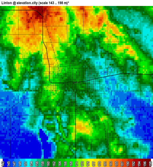
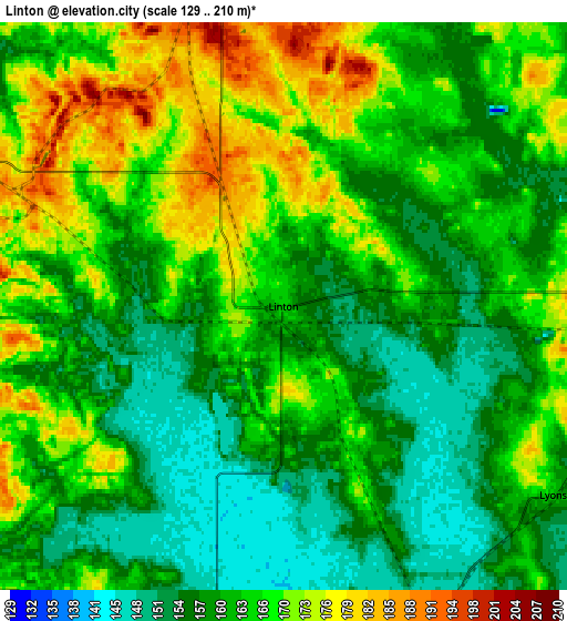
Below is the Elevation map of Linton, which displays elevation range with different colors. Scale of the first map is from 143 to 198 m (469 to 650 ft) with average elevation of 162 meters (=531 ft) [note 1]
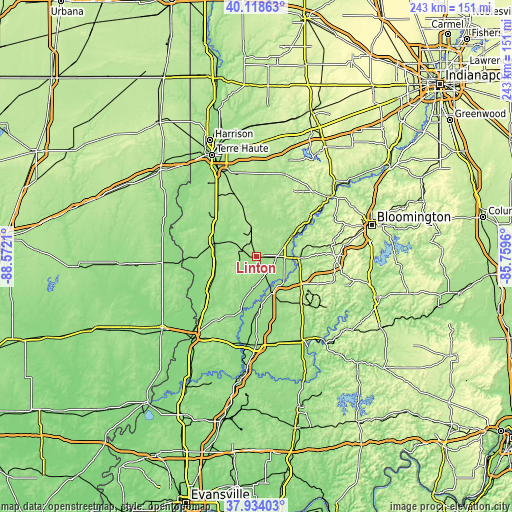
These maps also provides idea of topography and contour of this city, they are displayed at different zoom levels. More info about maps, scale and edge coordinates you can find below images.
| \ | Map #1 | Map #2 | Topo.Map |
| Scale [m] | 143..198 m | 129..210 m | × |
| Scale [ft] | 469..650 ft | 423..689 ft | × |
| Average | 162 m = 531 ft | 163.2 m = 535 ft | × |
| Width | 7.59 km = 4.7 mi | 15.18 km = 9.4 mi | 242.9 km = 150.9 mi |
| Height | 7.59 km = 4.7 mi | 15.18 km = 9.4 mi | 242.9 km = 150.9 mi |
| ↑Max Latitude | 39.068897° | 39.103007° | 40.11863° |
| Latitude at center | 39.03477° | 39.03477° | 39.03477° |
| ↓Min Latitude | 39.000627° | 38.966467° | 37.93403° |
| ← Min Longitude | -87.209795° | -87.253741° | -88.5721° |
| Longitude center | -87.16585° | -87.16585° | -87.16585° |
| →Max Longitude | -87.121905° | -87.077959° | -85.7596° |
Nearby cities:
Cities around Linton sort by population:
• Washington elevation 156 m
41.8 km,  180°
180°
• Sullivan 163 m
21.8 km,  288°
288°
• Middlebury 204 m
25.8 km,  9°
9°
• Bicknell 156 m
31.5 km,  202°
202°
• Bloomfield 184 m
19.7 km,  92°
92°
• Spencer 173 m
44.7 km,  51°
51°
• Jasonville 192 m
14.6 km,  348°
348°
• Worthington 156 m
19 km,  58°
58°
• Odon 165 m
26.1 km,  144°
144°
• Palestine 141 m
38.8 km,  264°
264°
• Shelburn 164 m
25.3 km,  309°
309°
• Farmersburg 171 m
30.2 km,  321°
321°
Multilingual:
 En español:
Linton elevación 165 m.
 En France:
Linton élévation 165 m.


Sources and notes:
- [note 1] Map square and city borders are not equal. Map elevation data is calculated only from area inside that square.
- [src 1] Elevation data from geonames database provided with same terms of usage.
- [src 2] The elevation map of Linton is generated using elevation data from NASA's 3 arcsec (90m) resolution SRTM data.
- [src 3] Base (background) map © OpenStreetMap contributors tiles are generated by Geofabrik and OpenTopoMap.
Copyright & License:
This Linton Elevation Map is licensed under CC BY-SA. You may reuse any part from this page, if you give a proper credit by linking to this URL:
 More info on terms of use page.