Bloomfield elevation
Bloomfield (Indiana, Greene County), United States elevation is 184 meters and Bloomfield elevation in feet is 604 ft above sea level [src 1]. Bloomfield is a seat of a second-order administrative division (feature code) with elevation that is 95 meters (312 ft) smaller than average city elevation in United States.
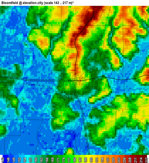
Below is the Elevation map of Bloomfield, which displays elevation range with different colors. Scale of the first map is from 143 to 217 m (469 to 712 ft) with average elevation of 167 meters (=548 ft) [note 1]
These maps also provides idea of topography and contour of this city, they are displayed at different zoom levels. More info about maps, scale and edge coordinates you can find below images.
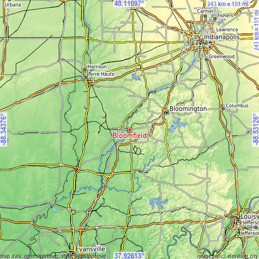
| \ | Map #1 | Topo.Map |
| Scale [m] | 143..217 m | × |
| Scale [ft] | 469..712 ft | × |
| Average | 167 m = 548 ft | × |
| Width | 7.59 km = 4.7 mi | 242.9 km = 150.9 mi |
| Height | 7.59 km = 4.7 mi | 242.9 km = 150.9 mi |
| ↑Max Latitude | 39.061121° | 40.11097° |
| Latitude at center | 39.02699° | 39.02699° |
| ↓Min Latitude | 38.992843° | 37.92613° |
| ← Min Longitude | -86.981455° | -88.34376° |
| Longitude center | -86.93751° | -86.93751° |
| →Max Longitude | -86.893565° | -85.53126° |
Nearby cities:
Cities around Bloomfield sort by population:
• Bloomington elevation 243 m
38.7 km,  66°
66°
• Ellettsville 212 m
35.4 km,  49°
49°
• Linton 165 m
19.7 km,  272°
272°
• Sullivan 163 m
41.1 km,  280°
280°
• Smithville-Sanders 222 m
37 km,  84°
84°
• Middlebury 204 m
30.7 km,  329°
329°
• Loogootee 165 m
39 km,  177°
177°
• Spencer 173 m
32.6 km,  27°
27°
• Jasonville 192 m
27.2 km,  303°
303°
• Worthington 156 m
11.5 km,  341°
341°
• Odon 165 m
21 km,  192°
192°
• Oolitic 173 m
38.3 km,  111°
111°
Multilingual:
 En español:
Bloomfield elevación 184 m.
 En France:
Bloomfield élévation 184 m.
 Auf Deutsch:
Bloomfield höhe über dem Meeresspiegel ist 184 m.

Sources and notes:
- [note 1] Map square and city borders are not equal. Map elevation data is calculated only from area inside that square.
- [src 1] Elevation data from geonames database provided with same terms of usage.
- [src 2] The elevation map of Bloomfield is generated using elevation data from NASA's 3 arcsec (90m) resolution SRTM data.
- [src 3] Base (background) map © OpenStreetMap contributors tiles are generated by Geofabrik and OpenTopoMap.
Copyright & License:
This Bloomfield Elevation Map is licensed under CC BY-SA. You may reuse any part from this page, if you give a proper credit by linking to this URL:
 More info on terms of use page.