Smithville-Sanders elevation
Smithville-Sanders (Indiana, Monroe County), United States elevation is 222 meters and Smithville-Sanders elevation in feet is 728 ft above sea level [src 1]. Smithville-Sanders is a populated place (feature code) with elevation that is 57 meters (187 ft) smaller than average city elevation in United States.
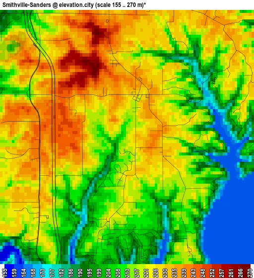
Below is the Elevation map of Smithville-Sanders, which displays elevation range with different colors. Scale of the first map is from 155 to 270 m (509 to 886 ft) with average elevation of 215.2 meters (=706 ft) [note 1]
These maps also provides idea of topography and contour of this city, they are displayed at different zoom levels. More info about maps, scale and edge coordinates you can find below images.
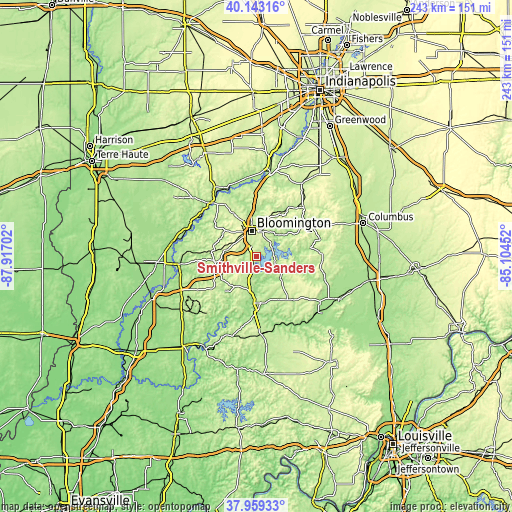
| \ | Map #1 | Topo.Map |
| Scale [m] | 155..270 m | × |
| Scale [ft] | 509..886 ft | × |
| Average | 215.2 m = 706 ft | × |
| Width | 7.59 km = 4.7 mi | 242.8 km = 150.9 mi |
| Height | 7.59 km = 4.7 mi | 242.8 km = 150.9 mi |
| ↑Max Latitude | 39.093805° | 40.14316° |
| Latitude at center | 39.05969° | 39.05969° |
| ↓Min Latitude | 39.025559° | 37.95933° |
| ← Min Longitude | -86.554715° | -87.91702° |
| Longitude center | -86.51077° | -86.51077° |
| →Max Longitude | -86.466825° | -85.10452° |
Nearby cities:
Cities around Smithville-Sanders sort by population:
• Bloomington elevation 243 m
11.8 km,  353°
353°
• Bedford 211 m
22.2 km,  174°
174°
• Martinsville 187 m
41.5 km,  9°
9°
• Ellettsville 212 m
21.7 km,  333°
333°
• Mitchell 209 m
36.5 km, 174°
• Bloomfield 184 m
37 km,  264°
264°
• Spencer 173 m
33.3 km,  319°
319°
• Orleans 193 m
44.5 km, 173°
• Worthington 156 m
41.1 km,  280°
280°
• Oolitic 173 m
17.7 km,  184°
184°
• Cordry Sweetwater Lakes 284 m
43.4 km,  51°
51°
• Nashville 186 m
27.8 km, 53°
Multilingual:
 En español:
Smithville-Sanders elevación 222 m.
 En France:
Smithville-Sanders élévation 222 m.
 Auf Deutsch:
Smithville-Sanders höhe über dem Meeresspiegel ist 222 m.
 На русском:
Smithville-Sanders высота над уровнем моря 222 м
Sources and notes:
- [note 1] Map square and city borders are not equal. Map elevation data is calculated only from area inside that square.
- [src 1] Elevation data from geonames database provided with same terms of usage.
- [src 2] The elevation map of Smithville-Sanders is generated using elevation data from NASA's 3 arcsec (90m) resolution SRTM data.
- [src 3] Base (background) map © OpenStreetMap contributors tiles are generated by Geofabrik and OpenTopoMap.
Copyright & License:
This Smithville-Sanders Elevation Map is licensed under CC BY-SA. You may reuse any part from this page, if you give a proper credit by linking to this URL:
 More info on terms of use page.