Mitchell elevation
Mitchell (Indiana, Lawrence County), United States elevation is 209 meters and Mitchell elevation in feet is 686 ft above sea level [src 1]. Mitchell is a populated place (feature code) with elevation that is 70 meters (230 ft) smaller than average city elevation in United States.
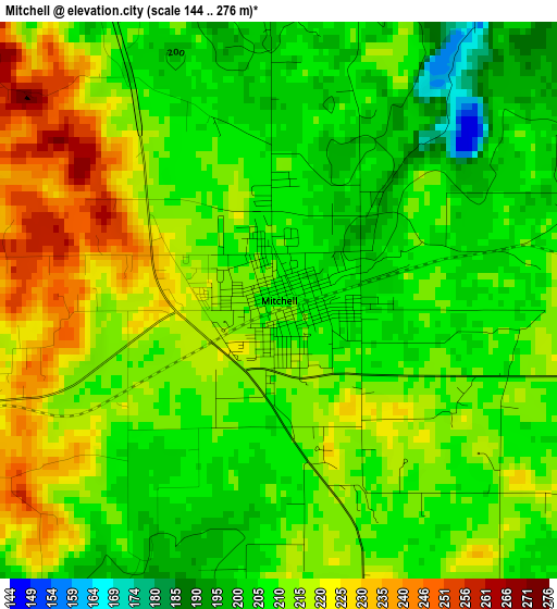
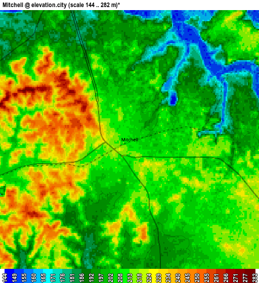
Below is the Elevation map of Mitchell, which displays elevation range with different colors. Scale of the first map is from 144 to 276 m (472 to 906 ft) with average elevation of 212.3 meters (=697 ft) [note 1]
These maps also provides idea of topography and contour of this city, they are displayed at different zoom levels. More info about maps, scale and edge coordinates you can find below images.
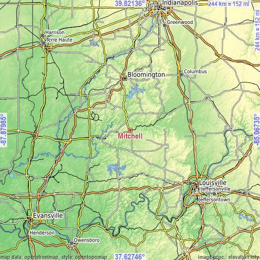
| \ | Map #1 | Map #2 | Topo.Map |
| Scale [m] | 144..276 m | 144..282 m | × |
| Scale [ft] | 472..906 ft | 472..925 ft | × |
| Average | 212.3 m = 697 ft | 207.1 m = 679 ft | × |
| Width | 7.62 km = 4.7 mi | 15.25 km = 9.5 mi | 243.9 km = 151.6 mi |
| Height | 7.62 km = 4.7 mi | 15.25 km = 9.5 mi | 243.9 km = 151.6 mi |
| ↑Max Latitude | 38.767102° | 38.801358° | 39.82136° |
| Latitude at center | 38.73283° | 38.73283° | 38.73283° |
| ↓Min Latitude | 38.698541° | 38.664236° | 37.62746° |
| ← Min Longitude | -86.517545° | -86.561491° | -87.87985° |
| Longitude center | -86.4736° | -86.4736° | -86.4736° |
| →Max Longitude | -86.429655° | -86.385709° | -85.06735° |
Nearby cities:
Cities around Mitchell sort by population:
• Bedford elevation 211 m
14.3 km,  355°
355°
• Salem 231 m
35.3 km,  113°
113°
• Paoli 192 m
19.6 km,  178°
178°
• Smithville-Sanders 222 m
36.5 km,  354°
354°
• Brownstown 191 m
40.8 km,  66°
66°
• Loogootee 165 m
38.7 km,  260°
260°
• Orleans 193 m
8.1 km,  166°
166°
• French Lick 154 m
24.1 km,  211°
211°
• Odon 165 m
46.5 km,  285°
285°
• Oolitic 173 m
19.2 km, 346°
• Shoals 155 m
28.5 km, 255°
• English 154 m
44.3 km, 178°
Multilingual:
 En español:
Mitchell elevación 209 m.
 En France:
Mitchell élévation 209 m.
 Auf Deutsch:
Mitchell höhe über dem Meeresspiegel ist 209 m.

Sources and notes:
- [note 1] Map square and city borders are not equal. Map elevation data is calculated only from area inside that square.
- [src 1] Elevation data from geonames database provided with same terms of usage.
- [src 2] The elevation map of Mitchell is generated using elevation data from NASA's 3 arcsec (90m) resolution SRTM data.
- [src 3] Base (background) map © OpenStreetMap contributors tiles are generated by Geofabrik and OpenTopoMap.
Copyright & License:
This Mitchell Elevation Map is licensed under CC BY-SA. You may reuse any part from this page, if you give a proper credit by linking to this URL:
 More info on terms of use page.