Martinsville elevation
Martinsville (Indiana, Morgan County), United States elevation is 187 meters and Martinsville elevation in feet is 614 ft above sea level [src 1]. Martinsville is a seat of a second-order administrative division (feature code) with elevation that is 92 meters (302 ft) smaller than average city elevation in United States.
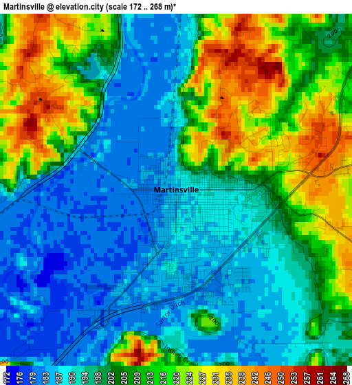
Below is the Elevation map of Martinsville, which displays elevation range with different colors. Scale of the first map is from 172 to 268 m (564 to 879 ft) with average elevation of 203 meters (=666 ft) [note 1]
These maps also provides idea of topography and contour of this city, they are displayed at different zoom levels. More info about maps, scale and edge coordinates you can find below images.
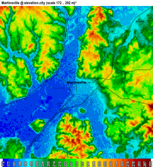
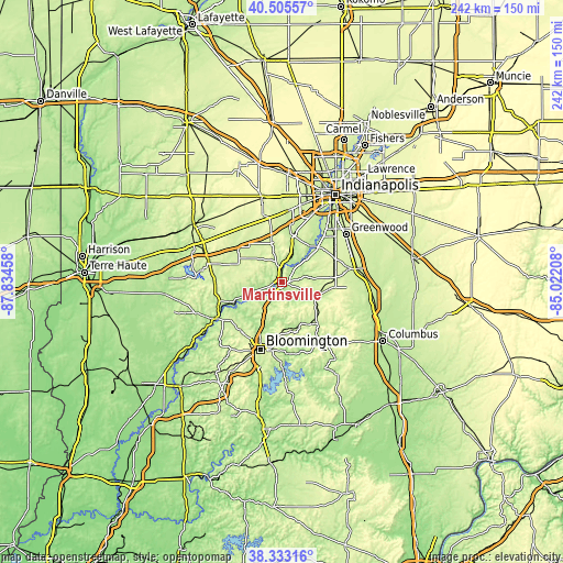
| \ | Map #1 | Map #2 | Topo.Map |
| Scale [m] | 172..268 m | 172..292 m | × |
| Scale [ft] | 564..879 ft | 564..958 ft | × |
| Average | 203 m = 666 ft | 212.2 m = 696 ft | × |
| Width | 7.55 km = 4.7 mi | 15.1 km = 9.4 mi | 241.5 km = 150.1 mi |
| Height | 7.55 km = 4.7 mi | 15.1 km = 9.4 mi | 241.5 km = 150.1 mi |
| ↑Max Latitude | 39.461766° | 39.495686° | 40.50557° |
| Latitude at center | 39.42783° | 39.42783° | 39.42783° |
| ↓Min Latitude | 39.393877° | 39.359908° | 38.33316° |
| ← Min Longitude | -86.472275° | -86.516221° | -87.83458° |
| Longitude center | -86.42833° | -86.42833° | -86.42833° |
| →Max Longitude | -86.384385° | -86.340439° | -85.02208° |
Nearby cities:
Cities around Martinsville sort by population:
• Bloomington elevation 243 m
30.4 km,  196°
196°
• Plainfield 224 m
30.8 km,  4°
4°
• Mooresville 219 m
21.1 km,  12°
12°
• Bargersville 252 m
24.6 km,  65°
65°
• Ellettsville 212 m
27.4 km,  218°
218°
• Waterloo 248 m
24.8 km,  52°
52°
• Brooklyn 207 m
13.4 km,  22°
22°
• Monrovia 246 m
17.4 km,  344°
344°
• Princes Lakes 254 m
29.6 km,  106°
106°
• Trafalgar 255 m
23.9 km,  93°
93°
• Cordry Sweetwater Lakes 284 m
30 km,  117°
117°
• Nashville 186 m
28.9 km,  148°
148°
Multilingual:
 En español:
Martinsville elevación 187 m.
 En France:
Martinsville élévation 187 m.
 Auf Deutsch:
Martinsville höhe über dem Meeresspiegel ist 187 m.

Sources and notes:
- [note 1] Map square and city borders are not equal. Map elevation data is calculated only from area inside that square.
- [src 1] Elevation data from geonames database provided with same terms of usage.
- [src 2] The elevation map of Martinsville is generated using elevation data from NASA's 3 arcsec (90m) resolution SRTM data.
- [src 3] Base (background) map © OpenStreetMap contributors tiles are generated by Geofabrik and OpenTopoMap.
Copyright & License:
This Martinsville Elevation Map is licensed under CC BY-SA. You may reuse any part from this page, if you give a proper credit by linking to this URL:
 More info on terms of use page.