Pelham elevation
Pelham (Georgia, Mitchell County), United States elevation is 119 meters and Pelham elevation in feet is 390 ft above sea level [src 1]. Pelham is a populated place (feature code) with elevation that is 160 meters (525 ft) smaller than average city elevation in United States.
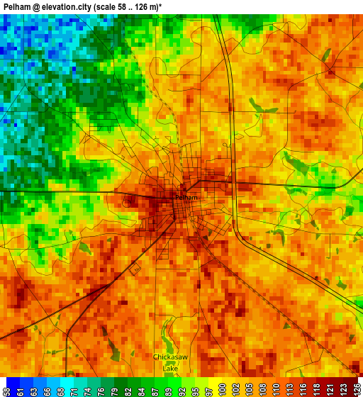
Below is the Elevation map of Pelham, which displays elevation range with different colors. Scale of the first map is from 58 to 126 m (190 to 413 ft) with average elevation of 101.1 meters (=332 ft) [note 1]
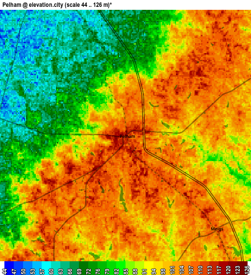
These maps also provides idea of topography and contour of this city, they are displayed at different zoom levels. More info about maps, scale and edge coordinates you can find below images.
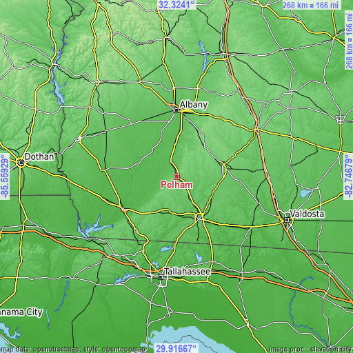
| \ | Map #1 | Map #2 | Topo.Map |
| Scale [m] | 58..126 m | 44..126 m | × |
| Scale [ft] | 190..413 ft | 144..413 ft | × |
| Average | 101.1 m = 332 ft | 91.8 m = 301 ft | × |
| Width | 8.37 km = 5.2 mi | 16.73 km = 10.4 mi | 267.7 km = 166.3 mi |
| Height | 8.37 km = 5.2 mi | 16.73 km = 10.4 mi | 267.7 km = 166.3 mi |
| ↑Max Latitude | 31.16563° | 31.203226° | 32.3241° |
| Latitude at center | 31.12802° | 31.12802° | 31.12802° |
| ↓Min Latitude | 31.090395° | 31.052755° | 29.91667° |
| ← Min Longitude | -84.196985° | -84.240931° | -85.55929° |
| Longitude center | -84.15304° | -84.15304° | -84.15304° |
| →Max Longitude | -84.109095° | -84.065149° | -82.74679° |
Nearby cities:
Cities around Pelham sort by population:
• Albany elevation 66 m
50.1 km,  359°
359°
• Thomasville 88 m
36.4 km,  152°
152°
• Moultrie 102 m
35.1 km,  80°
80°
• Bainbridge 45 m
47.3 km,  238°
238°
• Cairo 82 m
28.2 km,  189°
189°
• Sylvester 127 m
53.9 km,  33°
33°
• Camilla 58 m
12.7 km,  334°
334°
• Putney 65 m
38.2 km,  5°
5°
• Colquitt 60 m
55.4 km,  274°
274°
• Boston 68 m
51 km,  137°
137°
• Meigs 107 m
8.7 km, 135°
• Newton 48 m
26.9 km,  319°
319°
Multilingual:
 En español:
Pelham elevación 119 m.
 En France:
Pelham élévation 119 m.


Sources and notes:
- [note 1] Map square and city borders are not equal. Map elevation data is calculated only from area inside that square.
- [src 1] Elevation data from geonames database provided with same terms of usage.
- [src 2] The elevation map of Pelham is generated using elevation data from NASA's 3 arcsec (90m) resolution SRTM data.
- [src 3] Base (background) map © OpenStreetMap contributors tiles are generated by Geofabrik and OpenTopoMap.
Copyright & License:
This Pelham Elevation Map is licensed under CC BY-SA. You may reuse any part from this page, if you give a proper credit by linking to this URL:
 More info on terms of use page.