Colquitt elevation
Colquitt (Georgia, Miller County), United States elevation is 60 meters and Colquitt elevation in feet is 197 ft above sea level [src 1]. Colquitt is a seat of a second-order administrative division (feature code) with elevation that is 219 meters (719 ft) smaller than average city elevation in United States.
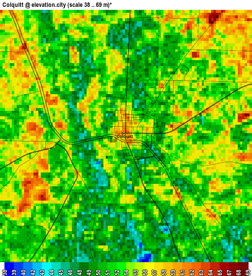
Below is the Elevation map of Colquitt, which displays elevation range with different colors. Scale of the first map is from 38 to 69 m (125 to 226 ft) with average elevation of 52.9 meters (=174 ft) [note 1]
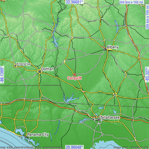
These maps also provides idea of topography and contour of this city, they are displayed at different zoom levels. More info about maps, scale and edge coordinates you can find below images.
| \ | Map #1 | Topo.Map |
| Scale [m] | 38..69 m | × |
| Scale [ft] | 125..226 ft | × |
| Average | 52.9 m = 174 ft | × |
| Width | 8.36 km = 5.2 mi | 267.6 km = 166.3 mi |
| Height | 8.36 km = 5.2 mi | 267.6 km = 166.3 mi |
| ↑Max Latitude | 31.208883° | 32.36681° |
| Latitude at center | 31.17129° | 31.17129° |
| ↓Min Latitude | 31.133682° | 29.96048° |
| ← Min Longitude | -84.777195° | -86.1395° |
| Longitude center | -84.73325° | -84.73325° |
| →Max Longitude | -84.689305° | -83.327° |
Nearby cities:
Cities around Colquitt sort by population:
• Bainbridge elevation 45 m
33.3 km,  153°
153°
• Camilla 58 m
50.2 km,  82°
82°
• Blakely 86 m
29.8 km,  320°
320°
• Chattahoochee 80 m
52.9 km,  191°
191°
• Donalsonville 51 m
20.1 km,  223°
223°
• Ashford 79 m
47.9 km,  271°
271°
• Malone 47 m
47.3 km,  239°
239°
• Morgan 81 m
42.7 km,  17°
17°
• Edison 94 m
43 km,  359°
359°
• Webb 88 m
52.3 km,  280°
280°
• Arlington 97 m
29.9 km,  1°
1°
• Newton 48 m
40.9 km,  67°
67°
Multilingual:
 En español:
Colquitt elevación 60 m.
 En France:
Colquitt élévation 60 m.


Sources and notes:
- [note 1] Map square and city borders are not equal. Map elevation data is calculated only from area inside that square.
- [src 1] Elevation data from geonames database provided with same terms of usage.
- [src 2] The elevation map of Colquitt is generated using elevation data from NASA's 3 arcsec (90m) resolution SRTM data.
- [src 3] Base (background) map © OpenStreetMap contributors tiles are generated by Geofabrik and OpenTopoMap.
Copyright & License:
This Colquitt Elevation Map is licensed under CC BY-SA. You may reuse any part from this page, if you give a proper credit by linking to this URL:
 More info on terms of use page.