Moultrie elevation
Moultrie (Georgia, Colquitt County), United States elevation is 102 meters and Moultrie elevation in feet is 335 ft above sea level [src 1]. Moultrie is a seat of a second-order administrative division (feature code) with elevation that is 177 meters (581 ft) smaller than average city elevation in United States.
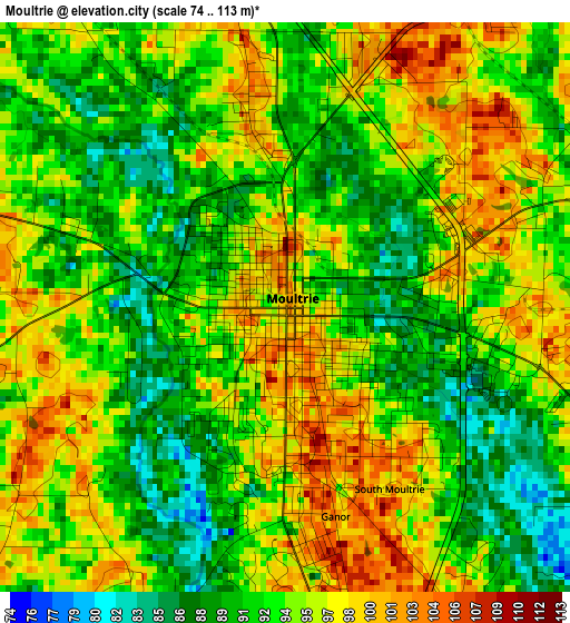
Below is the Elevation map of Moultrie, which displays elevation range with different colors. Scale of the first map is from 74 to 113 m (243 to 371 ft) with average elevation of 93.6 meters (=307 ft) [note 1]
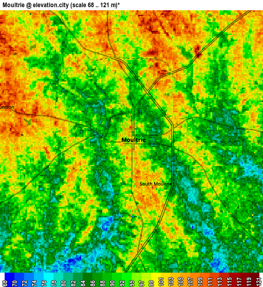
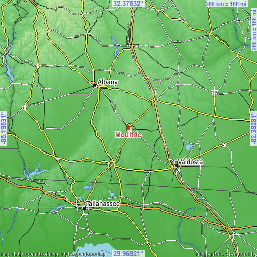
These maps also provides idea of topography and contour of this city, they are displayed at different zoom levels. More info about maps, scale and edge coordinates you can find below images.
| \ | Map #1 | Map #2 | Topo.Map |
| Scale [m] | 74..113 m | 68..121 m | × |
| Scale [ft] | 243..371 ft | 223..397 ft | × |
| Average | 93.6 m = 307 ft | 94.2 m = 309 ft | × |
| Width | 8.36 km = 5.2 mi | 16.72 km = 10.4 mi | 267.5 km = 166.2 mi |
| Height | 8.36 km = 5.2 mi | 16.72 km = 10.4 mi | 267.5 km = 166.2 mi |
| ↑Max Latitude | 31.2175° | 31.255075° | 32.37532° |
| Latitude at center | 31.17991° | 31.17991° | 31.17991° |
| ↓Min Latitude | 31.142305° | 31.104686° | 29.96921° |
| ← Min Longitude | -83.833005° | -83.876951° | -85.19531° |
| Longitude center | -83.78906° | -83.78906° | -83.78906° |
| →Max Longitude | -83.745115° | -83.701169° | -82.38281° |
Nearby cities:
Cities around Moultrie sort by population:
• Thomasville elevation 88 m
42.2 km,  205°
205°
• Tifton 109 m
40.2 km,  41°
41°
• Sylvester 127 m
39.3 km,  353°
353°
• Adel 75 m
35 km,  97°
97°
• Camilla 58 m
40.5 km,  278°
278°
• Pelham 119 m
35.1 km,  260°
260°
• Hahira 72 m
44.9 km,  117°
117°
• Sparks 77 m
33.5 km,  92°
92°
• Unionville 113 m
38.8 km, 43°
• Boston 68 m
43.1 km,  180°
180°
• Omega 101 m
25.8 km,  46°
46°
• Meigs 107 m
31 km,  247°
247°
Multilingual:
 En español:
Moultrie elevación 102 m.
 En France:
Moultrie élévation 102 m.
 Auf Deutsch:
Moultrie höhe über dem Meeresspiegel ist 102 m.

Sources and notes:
- [note 1] Map square and city borders are not equal. Map elevation data is calculated only from area inside that square.
- [src 1] Elevation data from geonames database provided with same terms of usage.
- [src 2] The elevation map of Moultrie is generated using elevation data from NASA's 3 arcsec (90m) resolution SRTM data.
- [src 3] Base (background) map © OpenStreetMap contributors tiles are generated by Geofabrik and OpenTopoMap.
Copyright & License:
This Moultrie Elevation Map is licensed under CC BY-SA. You may reuse any part from this page, if you give a proper credit by linking to this URL:
 More info on terms of use page.