Unionville elevation
Unionville (Georgia, Tift County), United States elevation is 113 meters and Unionville elevation in feet is 371 ft above sea level [src 1]. Unionville is a populated place (feature code) with elevation that is 166 meters (545 ft) smaller than average city elevation in United States.
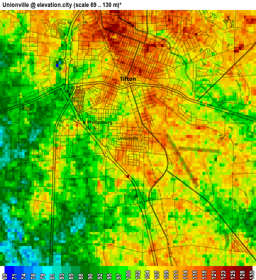
Below is the Elevation map of Unionville, which displays elevation range with different colors. Scale of the first map is from 69 to 130 m (226 to 427 ft) with average elevation of 102.9 meters (=338 ft) [note 1]
These maps also provides idea of topography and contour of this city, they are displayed at different zoom levels. More info about maps, scale and edge coordinates you can find below images.
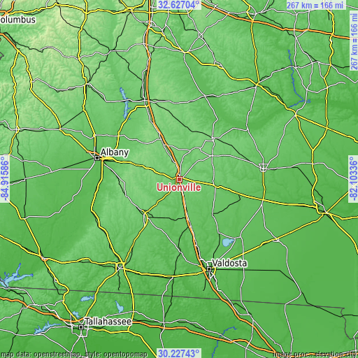
| \ | Map #1 | Topo.Map |
| Scale [m] | 69..130 m | × |
| Scale [ft] | 226..427 ft | × |
| Average | 102.9 m = 338 ft | × |
| Width | 8.34 km = 5.2 mi | 266.8 km = 165.8 mi |
| Height | 8.34 km = 5.2 mi | 266.8 km = 165.8 mi |
| ↑Max Latitude | 31.472398° | 32.62704° |
| Latitude at center | 31.43491° | 31.43491° |
| ↓Min Latitude | 31.397407° | 30.22743° |
| ← Min Longitude | -83.553555° | -84.91586° |
| Longitude center | -83.50961° | -83.50961° |
| →Max Longitude | -83.465665° | -82.10336° |
Nearby cities:
Cities around Unionville sort by population:
• Tifton elevation 109 m
1.7 km,  3°
3°
• Moultrie 102 m
38.8 km,  223°
223°
• Fitzgerald 110 m
39.5 km,  38°
38°
• Sylvester 127 m
32.8 km,  288°
288°
• Adel 75 m
34.1 km,  166°
166°
• Nashville 77 m
35.3 km,  135°
135°
• Ashburn 133 m
33.1 km,  335°
335°
• Ocilla 109 m
30.2 km,  54°
54°
• Sparks 77 m
30.6 km, 167°
• Willacoochee 78 m
45.2 km,  103°
103°
• Enigma 97 m
17.3 km, 98°
• Omega 101 m
13.1 km, 217°
Multilingual:
 En español:
Unionville elevación 113 m.
 En France:
Unionville élévation 113 m.
 Auf Deutsch:
Unionville höhe über dem Meeresspiegel ist 113 m.

Sources and notes:
- [note 1] Map square and city borders are not equal. Map elevation data is calculated only from area inside that square.
- [src 1] Elevation data from geonames database provided with same terms of usage.
- [src 2] The elevation map of Unionville is generated using elevation data from NASA's 3 arcsec (90m) resolution SRTM data.
- [src 3] Base (background) map © OpenStreetMap contributors tiles are generated by Geofabrik and OpenTopoMap.
Copyright & License:
This Unionville Elevation Map is licensed under CC BY-SA. You may reuse any part from this page, if you give a proper credit by linking to this URL:
 More info on terms of use page.