Lawrenceville elevation
Lawrenceville (Georgia, Gwinnett County), United States elevation is 326 meters and Lawrenceville elevation in feet is 1070 ft above sea level [src 1]. Lawrenceville is a seat of a second-order administrative division (feature code) with elevation that is 47 meters (154 ft) bigger than average city elevation in United States.
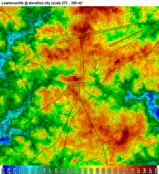
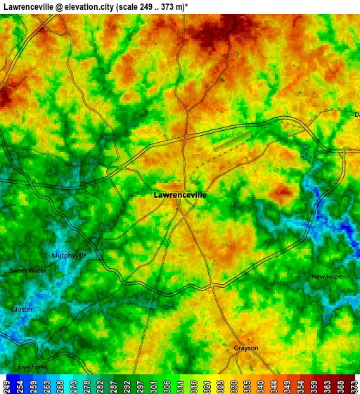
Below is the Elevation map of Lawrenceville, which displays elevation range with different colors. Scale of the first map is from 273 to 350 m (896 to 1148 ft) with average elevation of 315.8 meters (=1036 ft) [note 1]
These maps also provides idea of topography and contour of this city, they are displayed at different zoom levels. More info about maps, scale and edge coordinates you can find below images.
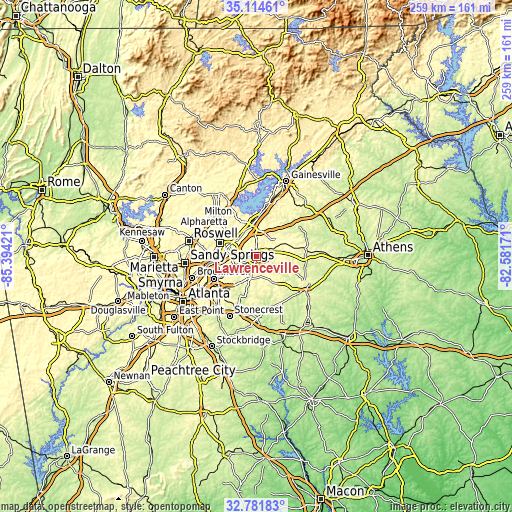
| \ | Map #1 | Map #2 | Topo.Map |
| Scale [m] | 273..350 m | 249..373 m | × |
| Scale [ft] | 896..1148 ft | 817..1224 ft | × |
| Average | 315.8 m = 1036 ft | 312.7 m = 1026 ft | × |
| Width | 8.11 km = 5 mi | 16.21 km = 10.1 mi | 259.4 km = 161.2 mi |
| Height | 8.11 km = 5 mi | 16.21 km = 10.1 mi | 259.4 km = 161.2 mi |
| ↑Max Latitude | 33.992653° | 34.029081° | 35.11461° |
| Latitude at center | 33.95621° | 33.95621° | 33.95621° |
| ↓Min Latitude | 33.919751° | 33.883277° | 32.78183° |
| ← Min Longitude | -84.031905° | -84.075851° | -85.39421° |
| Longitude center | -83.98796° | -83.98796° | -83.98796° |
| →Max Longitude | -83.944015° | -83.900069° | -82.58171° |
Nearby cities:
Cities around Lawrenceville sort by population:
• Duluth elevation 336 m
15.4 km,  289°
289°
• Sugar Hill 352 m
17.2 km,  345°
345°
• Snellville 324 m
11.4 km,  195°
195°
• Suwanee 314 m
13.1 km,  324°
324°
• Buford 360 m
18.3 km,  355°
355°
• Lilburn 290 m
16.1 km,  242°
242°
• Mountain Park 315 m
18 km,  226°
226°
• Loganville 308 m
15.3 km,  148°
148°
• Auburn 321 m
16.1 km,  66°
66°
• Dacula 320 m
9.1 km, 66°
• Grayson 334 m
7.5 km,  156°
156°
• Berkeley Lake 322 m
18.6 km,  279°
279°
Multilingual:
 En español:
Lawrenceville elevación 326 m.
 En France:
Lawrenceville élévation 326 m.
 Auf Deutsch:
Lawrenceville höhe über dem Meeresspiegel ist 326 m.

Sources and notes:
- [note 1] Map square and city borders are not equal. Map elevation data is calculated only from area inside that square.
- [src 1] Elevation data from geonames database provided with same terms of usage.
- [src 2] The elevation map of Lawrenceville is generated using elevation data from NASA's 3 arcsec (90m) resolution SRTM data.
- [src 3] Base (background) map © OpenStreetMap contributors tiles are generated by Geofabrik and OpenTopoMap.
Copyright & License:
This Lawrenceville Elevation Map is licensed under CC BY-SA. You may reuse any part from this page, if you give a proper credit by linking to this URL:
 More info on terms of use page.