Duluth elevation
Duluth (Georgia, Gwinnett County), United States elevation is 336 meters and Duluth elevation in feet is 1102 ft above sea level [src 1]. Duluth is a populated place (feature code) with elevation that is 57 meters (187 ft) bigger than average city elevation in United States.
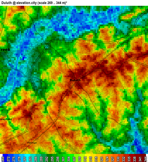
Below is the Elevation map of Duluth, which displays elevation range with different colors. Scale of the first map is from 269 to 344 m (883 to 1129 ft) with average elevation of 307.1 meters (=1008 ft) [note 1]
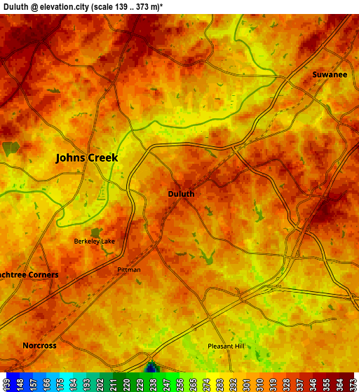
These maps also provides idea of topography and contour of this city, they are displayed at different zoom levels. More info about maps, scale and edge coordinates you can find below images.
| \ | Map #1 | Map #2 | Topo.Map |
| Scale [m] | 269..344 m | 139..373 m | × |
| Scale [ft] | 883..1129 ft | 456..1224 ft | × |
| Average | 307.1 m = 1008 ft | 308.4 m = 1012 ft | × |
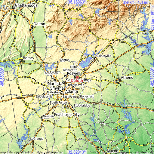
| Width | 8.1 km = 5 mi | 16.2 km = 10.1 mi | 259.2 km = 161.1 mi |
| Height | 8.1 km = 5 mi | 16.2 km = 10.1 mi | 259.2 km = 161.1 mi |
| ↑Max Latitude | 34.039303° | 34.075711° | 35.16063° |
| Latitude at center | 34.00288° | 34.00288° | 34.00288° |
| ↓Min Latitude | 33.966441° | 33.929987° | 32.82913° |
| ← Min Longitude | -84.188585° | -84.232531° | -85.55089° |
| Longitude center | -84.14464° | -84.14464° | -84.14464° |
| →Max Longitude | -84.100695° | -84.056749° | -82.73839° |
Nearby cities:
Cities around Duluth sort by population:
• Johns Creek elevation 293 m
5.8 km,  300°
300°
• Alpharetta 348 m
16 km, 300°
• Peachtree Corners 320 m
8 km,  242°
242°
• Lawrenceville 326 m
15.4 km,  109°
109°
• Tucker 342 m
17.8 km,  202°
202°
• Sugar Hill 352 m
15.4 km,  41°
41°
• Suwanee 314 m
8.7 km,  51°
51°
• Norcross 322 m
9.3 km,  222°
222°
• Lilburn 290 m
12.5 km,  179°
179°
• Mountain Park 315 m
17.7 km, 175°
• Doraville 327 m
17.3 km,  227°
227°
• Berkeley Lake 322 m
4.4 km, 241°
Multilingual:
 En español:
Duluth elevación 336 m.
 En France:
Duluth élévation 336 m.


Sources and notes:
- [note 1] Map square and city borders are not equal. Map elevation data is calculated only from area inside that square.
- [src 1] Elevation data from geonames database provided with same terms of usage.
- [src 2] The elevation map of Duluth is generated using elevation data from NASA's 3 arcsec (90m) resolution SRTM data.
- [src 3] Base (background) map © OpenStreetMap contributors tiles are generated by Geofabrik and OpenTopoMap.
Copyright & License:
This Duluth Elevation Map is licensed under CC BY-SA. You may reuse any part from this page, if you give a proper credit by linking to this URL:
 More info on terms of use page.