Tucker elevation
Tucker (Georgia, DeKalb County), United States elevation is 342 meters and Tucker elevation in feet is 1122 ft above sea level [src 1]. Tucker is a populated place (feature code) with elevation that is 63 meters (207 ft) bigger than average city elevation in United States.
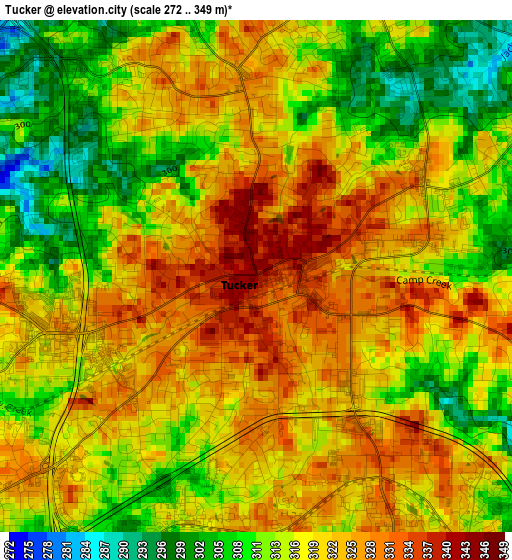
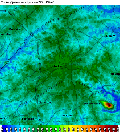
Below is the Elevation map of Tucker, which displays elevation range with different colors. Scale of the first map is from 272 to 349 m (892 to 1145 ft) with average elevation of 318.1 meters (=1044 ft) [note 1]
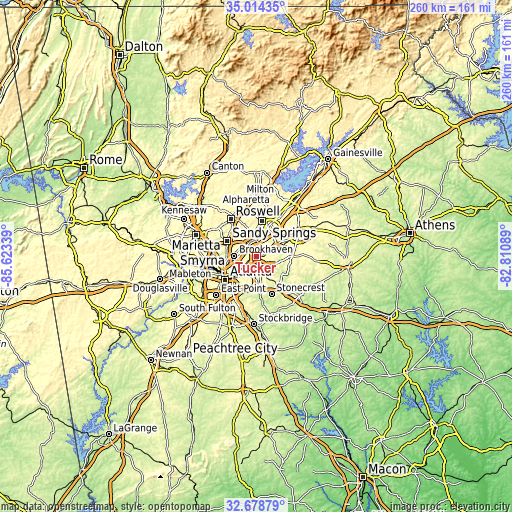
These maps also provides idea of topography and contour of this city, they are displayed at different zoom levels. More info about maps, scale and edge coordinates you can find below images.
| \ | Map #1 | Map #2 | Topo.Map |
| Scale [m] | 272..349 m | 245..508 m | × |
| Scale [ft] | 892..1145 ft | 804..1667 ft | × |
| Average | 318.1 m = 1044 ft | 306.7 m = 1006 ft | × |
| Width | 8.12 km = 5 mi | 16.23 km = 10.1 mi | 259.7 km = 161.4 mi |
| Height | 8.12 km = 5 mi | 16.23 km = 10.1 mi | 259.7 km = 161.4 mi |
| ↑Max Latitude | 33.891037° | 33.927508° | 35.01435° |
| Latitude at center | 33.85455° | 33.85455° | 33.85455° |
| ↓Min Latitude | 33.818048° | 33.78153° | 32.67879° |
| ← Min Longitude | -84.261085° | -84.305031° | -85.62339° |
| Longitude center | -84.21714° | -84.21714° | -84.21714° |
| →Max Longitude | -84.173195° | -84.129249° | -82.81089° |
Nearby cities:
Cities around Tucker sort by population:
• North Atlanta elevation 305 m
11.1 km,  276°
276°
• Chamblee 311 m
8.6 km,  298°
298°
• North Druid Hills 305 m
9.8 km,  244°
244°
• North Decatur 303 m
10.9 km,  229°
229°
• Norcross 322 m
9.6 km,  1°
1°
• Lilburn 290 m
7.9 km,  60°
60°
• Clarkston 309 m
5.4 km,  202°
202°
• Mountain Park 315 m
8.2 km,  98°
98°
• Doraville 327 m
7.8 km,  308°
308°
• Scottdale 313 m
8.4 km,  211°
211°
• Stone Mountain 321 m
6.7 km,  139°
139°
• Avondale Estates 322 m
10.3 km, 206°
Multilingual:
 En español:
Tucker elevación 342 m.
 En France:
Tucker élévation 342 m.


Sources and notes:
- [note 1] Map square and city borders are not equal. Map elevation data is calculated only from area inside that square.
- [src 1] Elevation data from geonames database provided with same terms of usage.
- [src 2] The elevation map of Tucker is generated using elevation data from NASA's 3 arcsec (90m) resolution SRTM data.
- [src 3] Base (background) map © OpenStreetMap contributors tiles are generated by Geofabrik and OpenTopoMap.
Copyright & License:
This Tucker Elevation Map is licensed under CC BY-SA. You may reuse any part from this page, if you give a proper credit by linking to this URL:
 More info on terms of use page.