Sugar Hill elevation
Sugar Hill (Georgia, Gwinnett County), United States elevation is 352 meters and Sugar Hill elevation in feet is 1155 ft above sea level [src 1]. Sugar Hill is a populated place (feature code) with elevation that is 73 meters (240 ft) bigger than average city elevation in United States.
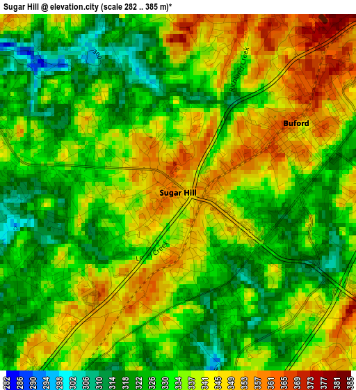
Below is the Elevation map of Sugar Hill, which displays elevation range with different colors. Scale of the first map is from 282 to 385 m (925 to 1263 ft) with average elevation of 334.7 meters (=1098 ft) [note 1]
These maps also provides idea of topography and contour of this city, they are displayed at different zoom levels. More info about maps, scale and edge coordinates you can find below images.
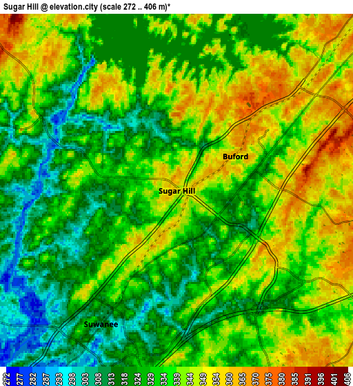
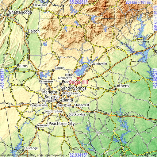
| \ | Map #1 | Map #2 | Topo.Map |
| Scale [m] | 282..385 m | 272..406 m | × |
| Scale [ft] | 925..1263 ft | 892..1332 ft | × |
| Average | 334.7 m = 1098 ft | 333.9 m = 1095 ft | × |
| Width | 8.09 km = 5 mi | 16.18 km = 10.1 mi | 258.9 km = 160.9 mi |
| Height | 8.09 km = 5 mi | 16.18 km = 10.1 mi | 258.9 km = 160.9 mi |
| ↑Max Latitude | 34.142869° | 34.179232° | 35.26281° |
| Latitude at center | 34.10649° | 34.10649° | 34.10649° |
| ↓Min Latitude | 34.070096° | 34.033686° | 32.93415° |
| ← Min Longitude | -84.077465° | -84.121411° | -85.43977° |
| Longitude center | -84.03352° | -84.03352° | -84.03352° |
| →Max Longitude | -83.989575° | -83.945629° | -82.62727° |
Nearby cities:
Cities around Sugar Hill sort by population:
• Johns Creek elevation 293 m
17.5 km,  240°
240°
• Peachtree Corners 320 m
23 km,  228°
228°
• Lawrenceville 326 m
17.2 km,  165°
165°
• Duluth 336 m
15.4 km,  221°
221°
• Suwanee 314 m
7 km,  209°
209°
• Buford 360 m
3.1 km,  59°
59°
• Auburn 321 m
21.6 km,  118°
118°
• Flowery Branch 341 m
13.3 km,  48°
48°
• Cumming 372 m
14.9 km,  318°
318°
• Dacula 320 m
18.1 km,  136°
136°
• Oakwood 351 m
19.2 km, 45°
• Berkeley Lake 322 m
19.6 km, 225°
Multilingual:
 En español:
Sugar Hill elevación 352 m.
 En France:
Sugar Hill élévation 352 m.
 Auf Deutsch:
Sugar Hill höhe über dem Meeresspiegel ist 352 m.

Sources and notes:
- [note 1] Map square and city borders are not equal. Map elevation data is calculated only from area inside that square.
- [src 1] Elevation data from geonames database provided with same terms of usage.
- [src 2] The elevation map of Sugar Hill is generated using elevation data from NASA's 3 arcsec (90m) resolution SRTM data.
- [src 3] Base (background) map © OpenStreetMap contributors tiles are generated by Geofabrik and OpenTopoMap.
Copyright & License:
This Sugar Hill Elevation Map is licensed under CC BY-SA. You may reuse any part from this page, if you give a proper credit by linking to this URL:
 More info on terms of use page.