Pamukkale elevation
Pamukkale (Denizli), Turkey elevation is 329 meters and Pamukkale elevation in feet is 1079 ft above sea level [src 1]. Pamukkale is a seat of a second-order administrative division (feature code) with elevation that is 394 meters (1293 ft) smaller than average city elevation in Turkey.
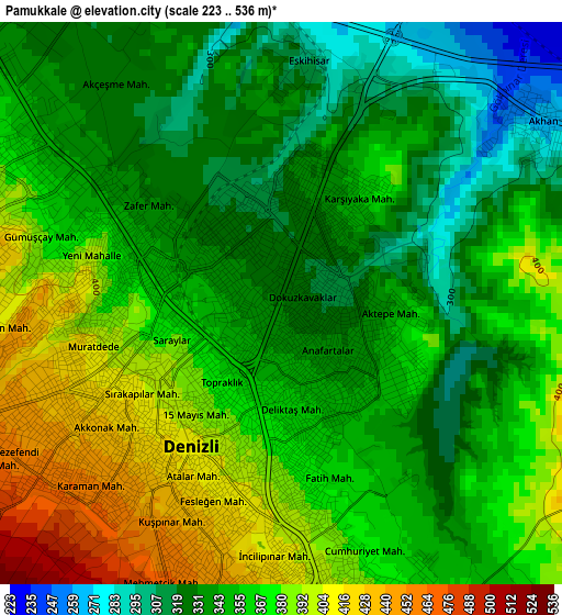
Below is the Elevation map of Pamukkale, which displays elevation range with different colors. Scale of the first map is from 223 to 536 m (732 to 1759 ft) with average elevation of 357.1 meters (=1172 ft) [note 1]
These maps also provides idea of topography and contour of this city, they are displayed at different zoom levels. More info about maps, scale and edge coordinates you can find below images.
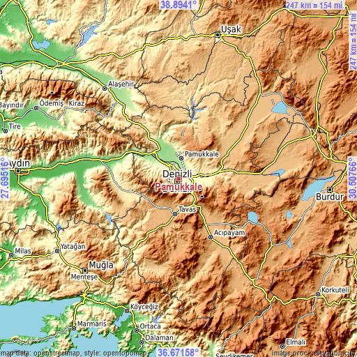
| \ | Map #1 | Topo.Map |
| Scale [m] | 223..536 m | × |
| Scale [ft] | 732..1759 ft | × |
| Average | 357.1 m = 1172 ft | × |
| Width | 7.72 km = 4.8 mi | 247.1 km = 153.5 mi |
| Height | 7.72 km = 4.8 mi | 247.1 km = 153.5 mi |
| ↑Max Latitude | 37.82592° | 38.8941° |
| Latitude at center | 37.7912° | 37.7912° |
| ↓Min Latitude | 37.756464° | 36.67158° |
| ← Min Longitude | 29.057465° | 27.69516° |
| Longitude center | 29.10141° | 29.10141° |
| →Max Longitude | 29.145355° | 30.50766° |
Nearby cities:
Cities around Pamukkale sort by population:
• Denizli elevation 405 m
2.3 km,  212°
212°
• Merkezefendi 439 m
5.4 km,  286°
286°
• Sarayköy 163 m
21.4 km,  313°
313°
• Serinhisar 958 m
27.5 km,  148°
148°
• Tavas 948 m
24.4 km,  186°
186°
• Pamukkale 255 m
14 km,  5°
5°
• Honaz 559 m
15.3 km,  104°
104°
• Buharkent 174 m
36.9 km,  301°
301°
• Babadağ 750 m
21.6 km,  274°
274°
• Akköy 212 m
18.5 km,  353°
353°
• Gözler 926 m
35.4 km, 7°
• Kızılcabölük 962 m
21.2 km,  200°
200°
Multilingual:
 En español:
Pamukkale elevación 329 m.
 En France:
Pamukkale élévation 329 m.
 Auf Deutsch:
Pamukkale höhe über dem Meeresspiegel ist 329 m.

Sources and notes:
- [note 1] Map square and city borders are not equal. Map elevation data is calculated only from area inside that square.
- [src 1] Elevation data from geonames database provided with same terms of usage.
- [src 2] The elevation map of Pamukkale is generated using elevation data from NASA's 3 arcsec (90m) resolution SRTM data.
- [src 3] Base (background) map © OpenStreetMap contributors tiles are generated by Geofabrik and OpenTopoMap.
Copyright & License:
This Pamukkale Elevation Map is licensed under CC BY-SA. You may reuse any part from this page, if you give a proper credit by linking to this URL:
 More info on terms of use page.