Honaz elevation
Honaz (Denizli), Turkey elevation is 559 meters and Honaz elevation in feet is 1834 ft above sea level [src 1]. Honaz is a seat of a second-order administrative division (feature code) with elevation that is 164 meters (538 ft) smaller than average city elevation in Turkey.
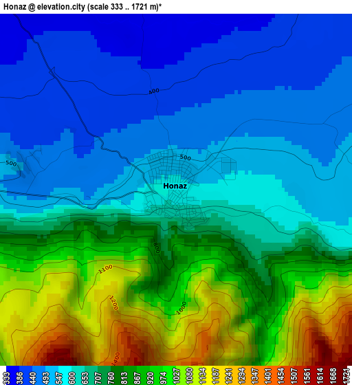
Below is the Elevation map of Honaz, which displays elevation range with different colors. Scale of the first map is from 333 to 1721 m (1093 to 5646 ft) with average elevation of 708.6 meters (=2325 ft) [note 1]
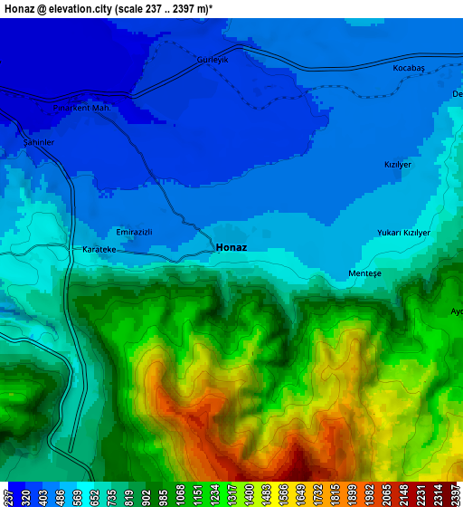
These maps also provides idea of topography and contour of this city, they are displayed at different zoom levels. More info about maps, scale and edge coordinates you can find below images.
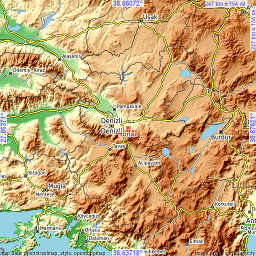
| \ | Map #1 | Map #2 | Topo.Map |
| Scale [m] | 333..1721 m | 237..2397 m | × |
| Scale [ft] | 1093..5646 ft | 778..7864 ft | × |
| Average | 708.6 m = 2325 ft | 793.2 m = 2602 ft | × |
| Width | 7.73 km = 4.8 mi | 15.45 km = 9.6 mi | 247.2 km = 153.6 mi |
| Height | 7.73 km = 4.8 mi | 15.45 km = 9.6 mi | 247.2 km = 153.6 mi |
| ↑Max Latitude | 37.792036° | 37.826755° | 38.86072° |
| Latitude at center | 37.7573° | 37.7573° | 37.7573° |
| ↓Min Latitude | 37.722548° | 37.68778° | 36.63718° |
| ← Min Longitude | 29.226015° | 29.182069° | 27.86371° |
| Longitude center | 29.26996° | 29.26996° | 29.26996° |
| →Max Longitude | 29.313905° | 29.357851° | 30.67621° |
Nearby cities:
Cities around Honaz sort by population:
• Denizli elevation 405 m
16.1 km,  276°
276°
• Merkezefendi 439 m
20.7 km, 284°
• Sarayköy 163 m
35.5 km,  301°
301°
• Serinhisar 958 m
19.6 km,  180°
180°
• Tavas 948 m
26.9 km,  220°
220°
• Pamukkale 255 m
22.2 km,  322°
322°
• Babadağ 750 m
36.7 km, 278°
• Bozkurt 861 m
30.8 km,  76°
76°
• Akköy 212 m
27.9 km, 322°
• Çardak 878 m
35.8 km, 77°
• Kızılcabölük 962 m
27.4 km,  233°
233°
• Pamukkale 329 m
15.3 km, 284°
Multilingual:
 En español:
Honaz elevación 559 m.
 En France:
Honaz élévation 559 m.


Sources and notes:
- [note 1] Map square and city borders are not equal. Map elevation data is calculated only from area inside that square.
- [src 1] Elevation data from geonames database provided with same terms of usage.
- [src 2] The elevation map of Honaz is generated using elevation data from NASA's 3 arcsec (90m) resolution SRTM data.
- [src 3] Base (background) map © OpenStreetMap contributors tiles are generated by Geofabrik and OpenTopoMap.
Copyright & License:
This Honaz Elevation Map is licensed under CC BY-SA. You may reuse any part from this page, if you give a proper credit by linking to this URL:
 More info on terms of use page.